|
Articles
Frequencies
1 Oct 2000
|
 Map of British Columbia.
Map by Mapblast
 Map showing the Thompson Subdivision of the Canadian
Pacific Railway.
Map showing the Thompson Subdivision of the Canadian
Pacific Railway.
Map by Mapblast
 BC Archives suggests a date of 1888 for this photo. Vancouver
Archives suggests that the locomotive is the "Nicola" (No. 6), one of
the new 4-4-0's purchased by Onderdonk in 1884, which was landed at Port Moody
on 21 May 1884. The box car is numbered 202 and is typical of the boxcars built
by Onderdonk at Yale.
BC Archives suggests a date of 1888 for this photo. Vancouver
Archives suggests that the locomotive is the "Nicola" (No. 6), one of
the new 4-4-0's purchased by Onderdonk in 1884, which was landed at Port Moody
on 21 May 1884. The box car is numbered 202 and is typical of the boxcars built
by Onderdonk at Yale.
 The original bridge in the photo above was removed then
installed over the Niagara Canyon on Vancouver Island and is still there in
2000. Traffic is now eastbound only across the bridge at Cisco due to the
shared trackage arrangement with Canadian National.
The original bridge in the photo above was removed then
installed over the Niagara Canyon on Vancouver Island and is still there in
2000. Traffic is now eastbound only across the bridge at Cisco due to the
shared trackage arrangement with Canadian National.
 Motorcyclists wait for 9500 west to clear the crossing.
Notice the colour of the water where the Fraser and Thompson Rivers meet
in the center of the photo.
Motorcyclists wait for 9500 west to clear the crossing.
Notice the colour of the water where the Fraser and Thompson Rivers meet
in the center of the photo.
 9500 west crosses the CN bridge at Lytton through the new
highway bridge construction. The grain cars, disappearing around a bend in
the canyon in the distance just to the right of the white construction tower,
show just how long trains can be.
9500 west crosses the CN bridge at Lytton through the new
highway bridge construction. The grain cars, disappearing around a bend in
the canyon in the distance just to the right of the white construction tower,
show just how long trains can be.
 5497 east with an SD45 leading followed by two
ex-Union Pacific units (5424-5426) lettered CP Rail crosses the
Trans-Canada Highway near Thompson.
5497 east with an SD45 leading followed by two
ex-Union Pacific units (5424-5426) lettered CP Rail crosses the
Trans-Canada Highway near Thompson.
 9502 west coal train at Spences Bridge westbound on CN
tracks heading for Roberts Bank on the pacific coast.
9502 west coal train at Spences Bridge westbound on CN
tracks heading for Roberts Bank on the pacific coast.
 9502 west on Canadian National trackage runs past Martel
nearing Spences Bridge as it hauls tonnage westward.
9502 west on Canadian National trackage runs past Martel
nearing Spences Bridge as it hauls tonnage westward.
 9681 east passes through Basque as it follows the
Thompson River to Nepa, Ashcroft, and eventually Kamloops, which is mile
0.0 of the Thompson Subdivision.
9681 east passes through Basque as it follows the
Thompson River to Nepa, Ashcroft, and eventually Kamloops, which is mile
0.0 of the Thompson Subdivision.
 Looking in a northerly direction the CN tracks are on
the left, CP on the right. The CN/CP junction at Nepa is just 1.1 miles
away in the distance.
Looking in a northerly direction the CN tracks are on
the left, CP on the right. The CN/CP junction at Nepa is just 1.1 miles
away in the distance.
 The tracks negotiate Black Rock Canyon between
Ashcroft and Basque.
The tracks negotiate Black Rock Canyon between
Ashcroft and Basque.
|
|

|
OK the
PK
 Here's a little Canadian railway slang
for you. If you own a scanner and listen to railway channels you've probably heard
"Okay the PK". PK being short for Pins and Knuckles. Okay the PK is called
to indicate a train has passed a pullby inspection which may be required at various
points along its trip. Persons stationed on either side of the train check the train
for defects such as dragging equipment (sight), hot journals (smell), and flat
wheels (sound) as it slowly rolls by them. Just one of many safety precautions
carried out by railway personnel during a working day. Here's a little Canadian railway slang
for you. If you own a scanner and listen to railway channels you've probably heard
"Okay the PK". PK being short for Pins and Knuckles. Okay the PK is called
to indicate a train has passed a pullby inspection which may be required at various
points along its trip. Persons stationed on either side of the train check the train
for defects such as dragging equipment (sight), hot journals (smell), and flat
wheels (sound) as it slowly rolls by them. Just one of many safety precautions
carried out by railway personnel during a working day.
The photos in this section of the web site were taken along Canadian Pacific's
Thompson Subdivision which runs between Kamloops, mileage 0.0, and ends at mileage
121.5, in North Bend British Columbia. For the Railfan, this sub is definitely,
Okay the PK. You won't find a better place to photograph trains. Besides following
safe practices around the railway you should also be on the lookout for rattlesnakes
in this subdivision. We startled a three footer while taking these photos. There are
also small cactii with barbs so sharp they stick into the soles of shoes, so watch
were you place your hands.
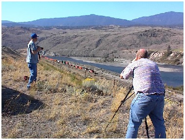
Patrick Lawson and Russ Watson photograph trains at
Basque where Canadian Pacific and Canadian National tracks run side by
side.
An agreement between Canadian Pacific and Canadian National to share tracks
through the Thompson and Fraser Canyons resulted in directional running in 1999. The
heaviest tonnage through the canyons is generally westbound. CN, with the flatter
grade, runs both CN and CP trains westbound beginning at Nepa located just south of
Ashcroft. The trains then separate, returning to their respective railways after
exiting the Fraser Canyon. Eastbound CN trains leave CN tracks at Matsqui Junction
for Mission where they join CP trackage for the eastward trip. They rejoin CN
trackage at Nepa. This arrangement is now the general operating practice but there
are exceptions to this procedure. A derailment, for example, would divert traffic to
the opposite railway.
Now, a little Canadian Pacific history...
18 May 1882
The Inland Sentinel
Things along the line of railway from Lytton to a point 12 miles above Yale
presents a busy scene of activity; work is being pushed at all points connected
therewith for an early completion of railway construction; Mr. Onderdonk with his
staff of Engineers and Division Superintendents has been busily engaged at several
points between Boston Bar and Kanaka flat in laying out work for the summer
operations; teams are met on the wagon road in large numbers loaded from the 12 mile
flat with plant and provisions for the work of this great undertaking; mile after
mile along the course of the winding Fraser enclosed in the narrow dale beneath the
clad mountains are seen clusters of tents and hoards of Chinese who seem to owe
their existence to the work of railway construction more than to the wealth of the
land; white labor is employed on the most dangerous and difficult points;
precipices which overhang the line of route through the canyons are progressing
fairly onward to completion. All work indicates, favorably that the whistle of the
"iron horse" will be heard echoing through the canyons of the Fraser this
fall.
And echo it did too during the fall of 2000 when these photos were taken.
Associated Links
Canadian Pacific Railway
Onderdonk's Way
© Copyright 2002 William C.
Slim
pacificcoast.net/~slim
|
|