
Articles

10
Images
To
view all the images associated with this article click on the camera above.
|
|
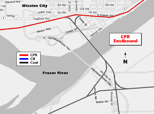
 1 Map 1 Map
|
Introduction
Canadian National and Canadian Pacific Railway have a track
sharing arrangement in the Fraser and Thompson Canyons. Mission City lies at the western junction (railway west) of
their shared trackage. Perhaps it might be interesting to examine the traffic patterns at this point.
History
The Canadian Pacific Railway was the first railway to operate trackage through the Fraser and Thompson Canyons.
Construction along this route was initiated by the federal government in 1880 when they hired Andrew Onderdonk, an
American of Dutch descent, to perform the work. Onderdonk held several contracts for the most difficult construction through the
canyons. As first on the scene Onderdonk had the best choice of a route through the canyons. Even so, the CPR wasn't
happy with his construction when it was transferred to them by the government. Years later, when what is today
called the Canadian National drove steel through the canyons, they were obliged to struggle along the opposite side
of the rivers on an even more forbidding route.
Several years ago the railways agreed to share tracks through the canyons in a so-called
"directional running zone" thereby permitting an increase in traffic. Generally, trains travel west on CN
tracks and eastward on CPR. There are exceptions of course, such as derailments, or land slips, or even the operation
of CPR's steam locomotive 2816, which usually runs against the flow of traffic on CPR's line.
This shared trackage begins in the east at Coho and Nepa which are located a short distance west (once again, railway
west) of Ashcroft. A track crossover between the two railways connects them. CN names the location Coho while CPR
calls it Nepa. The two places are a stones throw apart.
The junction on the western end might be considered to lie at the center of the bridge across the Fraser River at
Mission City. Mission City lies on the north bank while Matsqui rests on the south. This is a major connection point
for their co-production trackage, as the railways call it.
Mission Area Trackage
Mission seemed like it would be a choice location to photograph the many train movements. In addition to the main
lines there is also a CPR branch line with a diamond crossing of CN south to Abbotsford and Sumas on the international
border. Along the way there is another junction with the old BC Electric or BC Hydro, now named the Southern Railway
of British Columbia. A commuter operation, known as the Westcoast Express, operated by CPR on CPR trackage offers
Monday to Friday service between Mission City and CPR's old Vancouver station on Burrard Inlet. There are pedestrian
walkway connections from the station to the SeaBus and the SkyTrain which form part of Vancouver's transit system.
Westcoast Express trains depart Mission during the early mornings then return in the evening. There are five trains
in each direction spaced about 30 minutes apart.
Study the animated map at the top of this page which shows CPR and CN trackage at Mission. Red lines indicate common
CPR train movements, blue lines show CN movements, while a black line shows coal train movement of both railways. Note
that loaded coal trains only move in a westerly direction to Tsawwassen or North Vancouver. Empty coal trains return
eastbound on the path indicated. Note also that the animated map shows the movement of trains, NOT which running
trade employees are operating those trains. Consult the attached CPR press release below for more information.
 In January of 2006 the railways announced a new routing and switching agreement to cover the area between Boston Bar
on the CN line in the Fraser Canyon and ports at Roberts Bank and North Vancouver. These new changes are expected to
take place effective March 2006. This strategy is to help cope with the increase in container volumes expected to
increase from the present level of 2 million TEUs to 5-7 million TEUs by 2020.
In January of 2006 the railways announced a new routing and switching agreement to cover the area between Boston Bar
on the CN line in the Fraser Canyon and ports at Roberts Bank and North Vancouver. These new changes are expected to
take place effective March 2006. This strategy is to help cope with the increase in container volumes expected to
increase from the present level of 2 million TEUs to 5-7 million TEUs by 2020.
The Snapshots
Bring a long lens if you plan to shoot near CPR's wye at Mission. Access is blocked by fencing and industrial
buildings on the south side of CPR's main line. There is a private crossing into the wye but it is railway property
and you would be trespassing should you enter. DON'T become one of those trespassing statistics quoted by the
Railway Association of Canada.
Photo access to trains on the south shore in Matsqui presents few problems but you must remain aware of vehicular
traffic a well as rail traffic. Highway 11 can be quite busy.
There are 10 photos included with this article, most snapped around Mission, but one was taken at Hatzic, a short
distance east of Mission on CPR's main line. One other photo shows the local CPR way freight with CP 3005 still in
green paint passing the old semaphore signal at the Southern Railway of BC junction south of Mission.
Mapping Software
Streets & Trips is a mapping application sold by the Microsoft
Corporation. This article provides a downloadable file so you may locate photographs by their latitude and longitude
co-ordinates with mapping software on your computer. You require Microsoft Streets & Trips software
installed on your computer for this file to be useable.
Associated Links
Onderdonk's Way
Canadian Pacific Railway
Canadian National Railway
Southern Railway of British Columbia
Westcoast Express
Railway Association of Canada
District of Mission
Westminster Abbey
|
 |
|