By Omer S.A. Lavallee
Romeo, Juliet, Iago, Portia, Jessica, Lear and Othello. Seems like an unusual way to start an article about railroading, folk with a literary bent will of course, recognize characters from the plays of William Shakespeare. And while it was never the intention of the immortal bard that these names should serve for anything but the now-famous characterizations of his sixteenth century theatre business, mention them to any employee in train service or right-of-way maintenance, or indeed in any operating capacity on the Kettle Valley division, and you will find that they stir associations far removed from the Globe Theatre and Stratford upon Avon.
Along with several others, the foregoing names comprise those of the stations, section houses, and sidings
situated on the Coquihalla subdivision, which extends for 56.6 miles between Brookmere and Odlum, B.C. Most of this
subdivision is located within the very restricted confines of the gorge of the Coquihalla River, hence its name. It
vies with other sections of the Canadian Pacific's rail lines in terms of scenic grandeur as well as in engineering
accomplishment.
These features seem to be inseparable, to go hand in hand as it were. Few passengers take an interest in
the manner in which man has met the mighty challenge of nature, but those who do find a new satisfaction, entirely apart
from the pleasures of viewing glaciers, mountains, or swift-flowing mountain torrents. Perhaps, in another sense, it is
a tribute unknowingly paid to the members of the engineering profession that the traveller usually gives his closest
attention to the geographical features of a journey, but seldom ever thinks, much less is he concerned, about his own
security as he travels along. Nevertheless, few indeed have been the land obstacles which have not been tackled
successfully by railway engineers, the Company's lines in the Canadian Rockies are excellent examples of perseverance
and skill.
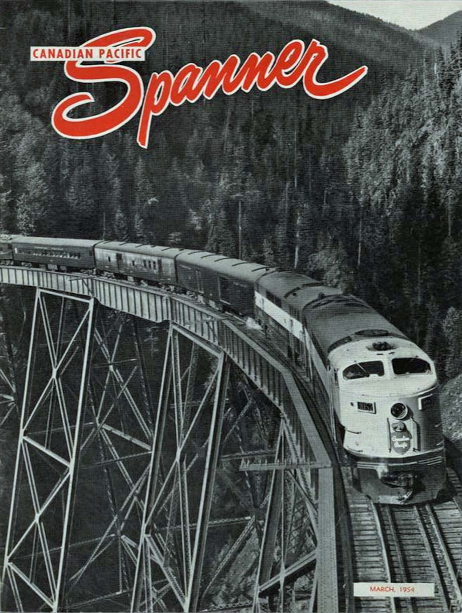
Recently, the Company's long-term modernization program was extended to the Kettle Valley and Kootenay divisions in southern British Columbia, and the powerful roar of diesel locomotives can be heard up and down the Coquihalla and its companion subdivisions which together make up the southern line through the Rocky Mountains. Where once the rock walls echoed the sound of the exhaust of powerful steam locomotives and the progress of a train could be traced on the Jura Loops east of Princeton, climbing the grades east and west out of Penticton, or high above the Lower Arrow Lake west of Castlegar, by the smoke clouds and plumes of steam from the locomotives, the diesel engine now threads the tortuous path of the Crowsnest-Coquihalla route, taking the grades unaided, indifferent to the extremes of weather. Only a matter of a few hours rail travel separates the temperate fruit-growing Okanagan valley, from the snows of the upper Coquihalla.
Dieselization of this line came about during the summer of 1953, and the Kootenay Express, train No. 11 and its eastward counterpart, the Kettle Valley Express, No. 12, are now diesel-hauled throughout their picturesque route of 850 miles between Lethbridge and Vancouver.
The route is fast becoming popular with travellers through the Rocky Mountains. Crowsnest Pass and Coquihalla Pass are, respectively, the easternmost and westernmost passes of the line, which has five other intervening major summits.
There is Crowsnest Pass itself, guarded at its eastern entrance by the mountain after which the pass is named, the long and picturesque descent into the Kootenay valley, another vista of the Kootenay and its neighboring mountains as the train climbs into Cranbrook. There is also Moyie Lake, whose shores are paralleled by the Crowsnest-Coquihalla route, the run along the rocky west shore of Kootenay Lake, after which the westward train takes its name, and the awe-inspiring picture of the Lower Arrow Lake framed in the coach or sleeping car window as the train climbs slowly up through the Bulldog Tunnel to Farron. These are features of the trip through southern British Columbia, but the most impressive section of all is the Coquihalla Gorge.
Shortly after the westbound train leaves Brookmere, it passes Brodie, the junction of the branch railway to
Nicola and Spences Bridge which loops away into the valley below the train. After rolling along for 14 miles through
the comparatively wide valley of the Coldwater River, the summit is reached at Coquihalla.
Within a very short distance, the scenery changes abruptly from the wooded and fertile Coldwater country
to the rugged, rocky, and treeless confines of the upper Coquihalla. From an elevation of 3,658 feet at Coquihalla
station, the twin ribbons of steel descend to a level of 144 feet at Hope on the Fraser River.
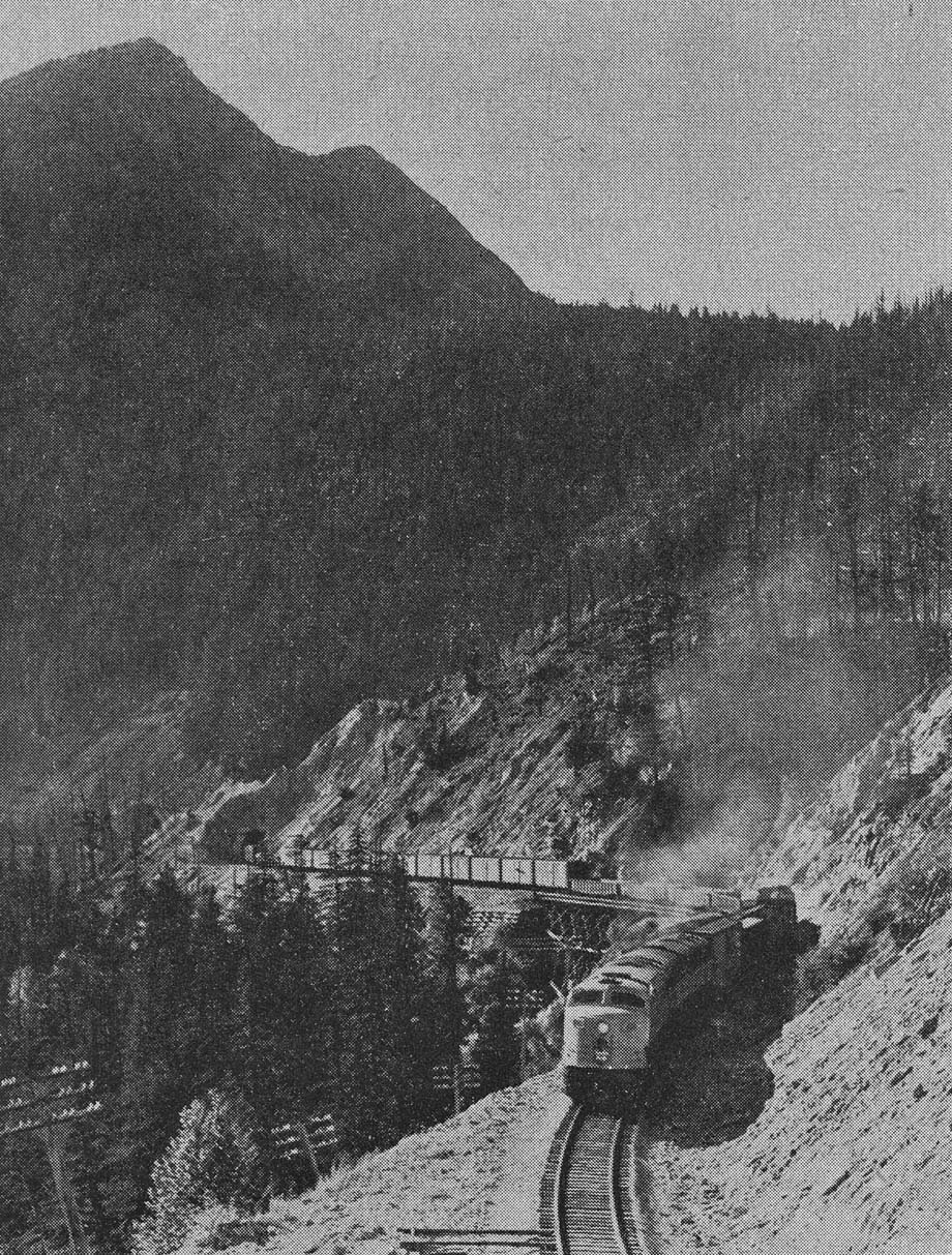
In the six miles lying between Coquihalla and Romeo, next siding to the west, the rails thread a half-dozen
tunnels and twice as many trestles. At one point, where the path of the railway crosses Cultus Creek, there is a
630-foot-long timber trestle, the largest timber bridge on the subdivision. The five mile section between Romeo and
Iago is marked by a number of snowsheds, to deflect the path of avalanches from the railway line. Between Iago and
Portia, and between Portia and Jessica, the course of the railway along the northerly slope of the canyon is
interrupted by two creeks draining into the Coquihalla.
At these points, the mouth of the connecting valley was thought too wide to be bridged at reasonable
cost, and it was consequently found necessary to divert the railway. These diversions served another important purpose
in that they permitted the mileage to be increased, thus preserving the 2.2 percent maximum grade envisioned during
construction. This line-lengthening to ease grades can be seen to better advantage on the main line between Stephen
and Field, B.C., where the confined space did not permit lengthening the railway in the open to ease the grade, hence
the construction of the two well-known spiral tunnels.
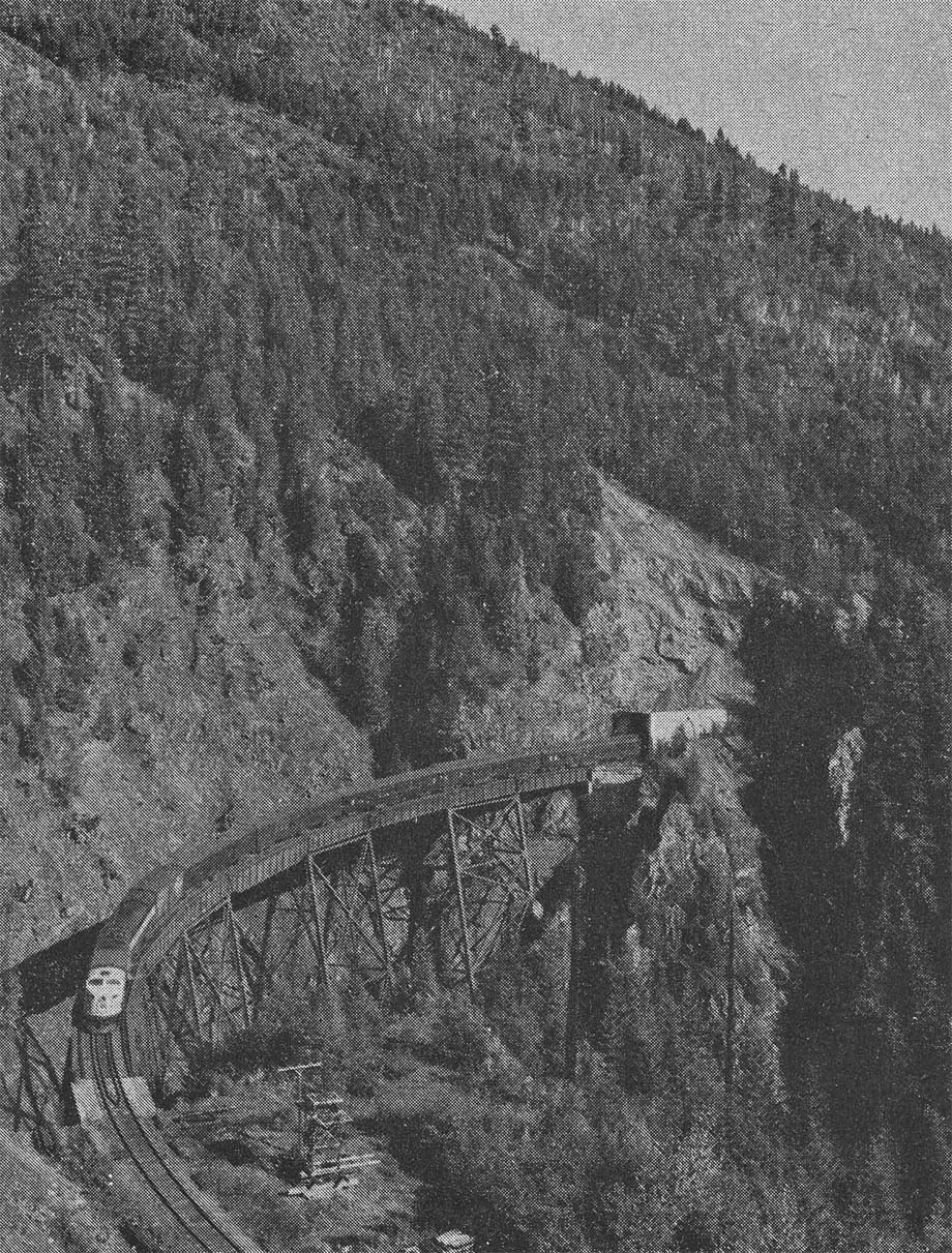
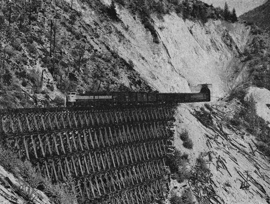
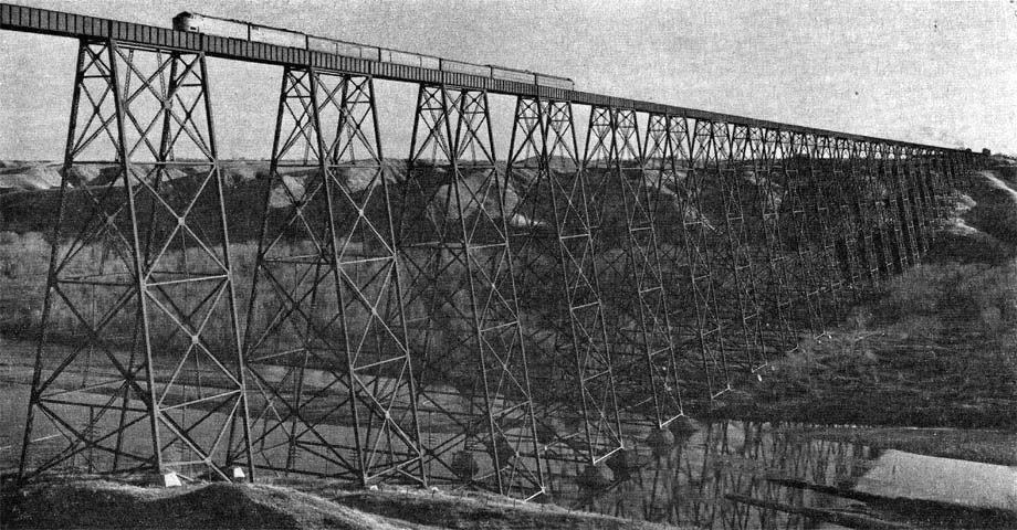
Boston Bar creek is the first interruption of this kind for the westbound traveller and the roadbed makes a one-mile detour up the valley of the creek to a point sufficiently narrow to allow of the construction of a bridge. At this point, the railway is carried across the creek far below by a 340-foot bridge, which has a 70-foot steel span. Gaining the west bank of the creek, the line is carried back to the Coquihalla gorge. Just a few miles to the west lies Ladner Creek which intersects the Coquihalla in the same manner. At this point, the actual diversion is not as extensive as at Boston Bar Creek but the 540-foot steel bridge which is used to bridge the stream some 200 feet below is perhaps the most spectacular structure on the line.
The rails, leaving a tunnel in the east wall of the valley plunge simultaneously upon this bridge, which is on a curve and grade as well.
The remaining portion of the line to the Fraser River at Hope is a succession of bridges, trestles, and tunnels, while the railway gradually lowers itself to the valley floor from the ledges of the upper canyon. Lest it concede defeat too easily to the persistence of man in successfully constructing the railway through its gorge, the capricious Coquihalla River threw one final difficult obstacle in the path of the line only five miles from its confluence with the Fraser.
Just west of Othello, at mile 49.5, the river plunges into a narrow, perpendicular-walled gorge which winds
in serpentine fashion back and forth across the path of the rail line. This difficult stretch is negotiated by means of
three bridges across the boiling stream, with four tunnels through the intervening rock faces. The four tunnels are on
tangent track and leaving them, it is possible to look back from the rear of a train and see the tunnels and bridges
simultaneously. West of the tunnels, the railway rolls over the level and comparatively wide Fraser valley, through
Hope and across the 955-foot Fraser River bridge to the junction with the main line two miles further on at
Odlum.
In the 36 miles between Coquihalla and Hope, the railway descends 3,500 feet on a maximum grade of 2.2
percent. In this section, there are 40 trestles and bridges as well as 16 tunnels and snowsheds. As if these conditions
were not enough, the Coquihalla country experiences some of the heaviest snowfalls in Canada, occasionally exceeding
600 inches per annum. The trestles and bridges between Coquihalla and Hope alone have an aggregate length of nearly
9,000 feet. while this same section has more than 3,000 feet of tunnel and 1,600 feet of snowshed.
The building of the railway through what is undoubtedly one of the most difficult sections in Canada, topographically speaking, is a tribute to the genius of the Chief Engineer of the former Kettle Valley Railway, the late Andrew McCulloch, who played an important part in locating and constructing, not only the Coquihalla subdivision, but other sections of the Kettle Valley line as well. The Coquihalla subdivision was the last portion of the Kettle Valley railway to be opened for service and this occurred on 31 Jul 1916. The railway had been surveyed as early as 1912, and it is interesting to note that an original proposal envisaged the construction of two railways through the valley.
In addition to the Kettle Valley Railway, a subsidiary of the C.P.R., which actually accomplished the construction of the line, a survey had been made at an earlier date by the Vancouver Victoria & Eastern Railway (VV&E) which was the name chosen by the Great Northern Railway of the United States for some of its lines in Canada. At first, nothing short of two railways would suffice and it was observed that they would be constructed, one on each side of the defile, for about 10 miles west of Coquihalla summit. At this point, it was the VV&E's intention to cross the valley to the Kettle Valley side. Mr. McCulloch observed at the time that it would be practically impossible to construct two lines around loops at Boston Bar Creek and Ladner Creek, and eventually an agreement was reached whereby the Kettle Valley line would be constructed and would be used by both companies. Finally, the VV&E withdrew.
The first train of the Kettle Valley Railway to pass over the completed Coquihalla subdivision was operated at the end of July, 1916, grading and construction having been delayed by the war, and by the unusually heavy snowfall and long winter seasons during the construction years. Frequently, the snow paralyzed work from the end of November to the end of May. Even at the present time, passengers on trains travelling through the upper reaches of the canyon in June, often see large patches of snow.
As the illustrations show, there is hardly an appreciable stretch of straight track on the line. Someone once suggested to the author that the number of degrees of curvature should be ascertained, to enable the number of complete circles of track represented by the curves to be given. This would appear to be an impossible task, even for an engineer. By reason of the alignment, it is possible, at many points on the subdivision, to look back along the canyon and see two or three bridges and several tunnel mouths simultaneously. However, there is something to be said for the location of the track, notwithstanding its winding character.
The railway descends 3,500 feet in slightly more than 36 miles or better than 96 feet to the mile. This means that it descends at an average rate of almost two percent. These figures, compared to the fact that the maximum grade has been kept to two and one-fifth percent over the whole distance is a tribute to Andrew McCulloch and his locating men. It means simply that the track inclination has been maintained at an almost uniform grade despite intervening ridges which had to be tunnelled, and valleys and streams which had to be bridged. Looking closely, for example at the Ladner Creek structure, it will be seen that the bridge deck girders are slightly, but obviously inclined when compared with the upper members of the steel supporting towers.
The dieselization of the Kettle Valley route is an acknowledgment of the growing importance of the Canadian Pacific's alternate route through the southern Rockies, a route considered by some to be superior from the scenic point of view, to the much-publicized main line via Glacier. Time alone will serve to confirm or deny this statement, but with the inauguration of the newest type of passenger train equipment due to take place shortly in the Canadian Pacific's transcontinental service, many thousands more will be encouraged to make the acquaintance of the Canadian Rockies. They will get to know and appreciate the beautiful scenery which has been placed by a benevolent nature in Canada's back yard, of which the Coquihalla Pass and its associated regions form no small part.
 Railway Limited and is reprinted here with their permission. All photographs, logos, and
trademarks are the property of the Canadian Pacific Railway Company.
Railway Limited and is reprinted here with their permission. All photographs, logos, and
trademarks are the property of the Canadian Pacific Railway Company.
