Vol. 17 No. 8
August, 1987
|
Stay Safe in 87
|
|

Early West
Blossoms
with Irrigation
|
Dave Jones
|
The original contract between the Canadian government and the Canadian Pacific
Railway provided the company with $25 million and 25 million acres (10.2 million hectares) of land in exchange for
undertaking the completion of the main line to the Pacific Ocean.
The intention was that the CPR would receive alternate sections of land in a checker-board pattern,
along a 40-kilometre-wide belt on either side of the rail line from Lake of the Woods to the Rocky
Mountains.
The agreement stipulated that the land be "fairly fit for settlement", creating a problem which soon became
apparent: there was not enough acreage in the "railway belt" for the government to fulfil its
obligation. Not only was most of the land in Manitoba and Ontario spoken for, but all of the land between Moose Jaw
and the Rockies was rejected by the CPR as being too arid for agricultural settlement.
Experimental farms had been established in the early 1880s to encourage settlement in this area, and had initially
shown great promise, but a return to dry conditions for a number of years caused the attempt to fail.
Prime Minister Wilfrid Laurier was anxious to complete the arrangement and imposed a deadline of June 1904, for the
selection of the remaining lands. Fortunately a decision was arrived at that was acceptable to both the government
and the CPR.
"The Last Best West" Promoted
William Pearce, a long time promoter of irrigation on the southern prairies and a senior official with the department
of the interior, suggested that, in lieu of the receipt of lands in the established checker-board
pattern, the railway accept a solid 1.21 million hectares, a 72-kilometre-wide block between Medicine
Hat and Calgary, and the remaining 324,000 hectares on the northern prairies.
In the 15 years which had elapsed since the completion of the main line, conditions had placed these lands in a much
more favorable light.
Several studies suggested the feasibility of successfully irrigating the area, hardy strains of wheat with shorter
growing seasons had been developed, markets and prices for grain were on the rise, and the high cost of land in the
United States had encouraged promoters to advertise the Canadian prairies as "the last best west".
Such was then-Chairman Sir William Van Horne's enthusiasm for the project that he predicted the area
would soon "fairly stink with blossoms through irrigation".
Since William Pearce could not be lured away from government to manage the irrigation scheme, another able man, with
years of experience as a government surveyor, was found in John S. Dennis.
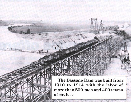
Bassano Dam Still Going Strong
Under Mr. Dennis' guidance the irrigation block was divided into three sections suggested by topographical
characteristics. The central section was deemed unsuitable for irrigation and was set aside for ranch land.
Irrigating the western section was relatively easy, requiring a simple diversion of the Bow River into a natural
hollow which served as a reservoir for the system. It was placed in operation in 1910.
The eastern section, however, required one of the most extensive projects of its kind on the continent to complete
the network. Central to the plan was the Bassano Dam, built across the horseshoe bend of the Bow River at Bassano,
Alberta.
To construct a reservoir at a sufficient elevation to feed water through the proposed system of canals, a
2,100-metre embankment, consisting of 283,170 cubic metres of earth was built, with a
100-metre concrete spillway completing the northern end of the dam.
By 26 Apr 1914, when CPR president Sir Thomas Shaughnessy officially opened the Bassano Dam, more than
2,832 cubic metres of water a second could pass through the sluice gates.
Now, more than 70 years later, the seasons have taken their toll, and some of the systems have been completely
abandoned in favor of new irrigation works. The Bassano Dam, however, is still going strong, and has been upgraded
over the last few years. An official "re-opening" of the dam late in July, marked the
beginning of many more years of active service.
This CP Rail News article is copyright
1987 by the Canadian Pacific Railway and is reprinted here with
their permission. All photographs, logos, and trademarks are the property of the Canadian Pacific Railway
Company.
|