|
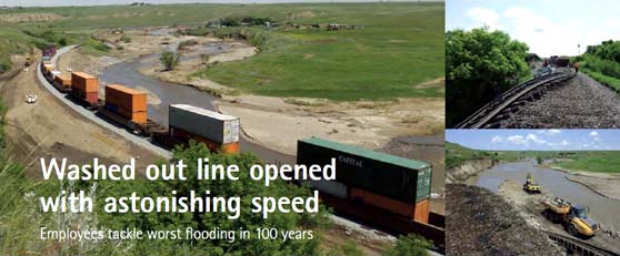
On 29 Jun 2010, our main line east of Medicine Hat, Alberta, closed since
18 Jun 2010, re-opened to traffic. Heavy rain, deemed to be the worst in 100 years (500 years in some locations), washed out portions of
our main line in southeastern Alberta and southwestern Saskatchewan. The Trans-Canada Highway was also closed and a state of emergency
declared in nine municipal jurisdictions after extensive flood damage was inflicted upon businesses and homes.
Quick action by Field Operations and Transportation ensured crews were protected and no injuries resulted. Emergency operation centres
were established in Gulf Canada Square and in our Dunmore, Alberta, field office to assess the damage to our infrastructure and begin
recovery operations.
Our account managers and customer service teams quickly reached out to customers to provide them with regular updates as it related to our
operations and their shipments.
During the 11-day outage we used both secondary network routes and detour routes on other railways to minimize impacts to our supply
chain. Field Operations and Transportation kept traffic moving through the complex system of detours and re-routes.
Coordinated by local management working closely with the NMC, and with considerable assistance from local union representatives, running
trades employees from across Alberta, Saskatchewan, and Manitoba were deployed into action. Managers from various service areas were also
called on to assist with the familiarization process.
The result: we were able to minimize the flood's impact on our operations and keep traffic moving safely.
For engineering crews, the first priority was to restore operations east of Dunmore between miles 108.3 and 109.3, a critical bottleneck.
Initially, both road and rail access to the site was non-existent. The location included long stretches of severely damaged track, some of
it suspended in mid-air above washed out sections of embankment.
In all, 10,000 cubic metres of material was required to rebuild the embankment and track.
Mile 144.1, west of Dunmore, required the most work. In total, 800 linear feet of embankment had been lost. More than 200 car loads of
riprap were used to protect the embankment from further erosion, enough to fill about nine and a half Olympic swimming pools. Twenty new
track panels were installed.
Environmental damage also resulted from the flooding. Ross Creek, which flows immediately north of the Maple Creek subdivision, shifted
onto our right-of-way during the massive rainfall, resulting in the loss of a large piece of the road bed at mile 144.1. The first stage
of reconstruction was creating a berm to separate Ross Creek from our right-of-way.
CP's Environmental Services team consulted with three levels of government for all remediation. In Canada, fish-bearing streams such as
Ross Creek are regulated by the Federal Department of Fisheries and Oceans. Discharges in Alberta are regulated by Alberta's Environment
Department, and the area surrounding mile 144.1 is managed by the City of Medicine Hat Parks and Outdoor Recreation.
Many residents also faced a long summer of clean-up as they worked to restore their homes and lives. In Irvine, Alberta, one of the most
impacted, CP helped the community by donating $2,500 to the Irvine Flood Relief Fund through the Red Cross. With the assistance of our
Strategic Sourcing Group, we also provided emergency supplies to help with the clean-up.
Given the amount of damage over such a widespread stretch of track, the speed with which we were able to reopen the line was astounding,
a testament to the dedication and professionalism of all engineering, mechanical, and operations employees.
|