

Kamloops British Columbia - Have you ever wondered about some of the names along the 121.5 mile
stretch of railway between Kamloops and North Bend that is known as the Thompson Subdivision (Canadian Pacific) and
the Ashcroft Subdivision (Canadian National)?
Some of the station names, such as Kamloops, Savona, Walhachin, Ashcroft, Spences Bridge, and Lytton, are obvious, as
the communities they served still exist, and the meaning behind the names is not hard to find.
Others, however, including Benledi, Nepa, Toketic, and Drynoch on the CP line, and Kissick, Jaleslie, Lasha, and
Inkitsaph on CN, are not as obvious when it comes to finding out why they carry the names they do, or what those names
mean.
In 1947, the Ashcroft Journal noted that there were some 22 trains per day running along the CP line through this
stretch of railway, with 10 of those trains being intercontinental passenger trains.
There were stations large and small along the route, and these station names remain, even though in many cases the
stations themselves are long gone.
Today the CP line through the Thompson Subdivision carries as many as three dozen trains (or more) per day, almost
exclusively freight trains.
These trains are considerably longer than their 1947 counterparts, which would probably have been in the range of
2,000 feet long, today, freight trains can reach lengths of up to 14,000 feet, or close to three miles.
This article looks at the station names on the CP line from Kamloops to Ashcroft, the second part will look at the
station names on the CP line from Black Canyon to North Bend.
A future article will look at the CN station names in the same stretch, although there is considerable duplication
between the names.
While the official term for the signs is station names, they do not necessarily mean there was an actual station
there, they can also indicate the presence of such things as sidings, connections, or signals.
The station name signs are parallel to the tracks, CP also has mile board signs at a right angle to the tracks a mile
out from the station name sign.
The mile board sign for Dodge east of Savona can be seen from Highway 1 just as the highway starts the climb up Six
Mile Hill.
Also worth noting is that while the two railways operate their own lines, there is an agreement between them to have
"directional running" along the Thompson and Fraser Rivers between Nepa (west of Ashcroft) and Mission in the
Cascade Subdivision (CP)/Yale Subdivision (CN), with a few exceptions, all trains travelling east between these points
use the CP tracks, while all trains travelling west use the CN line.
KAMLOOPS (Mile 0): The site at the junction of the North and South Thompson Rivers has always been an important
settlement for the Secwepemc people. Its name is an English transliteration of the Secwepemc word Tk'emlups, meaning
"meeting of the waters". The first European explorers arrived there in 1811, and in 1812 it became a fur
trading post called "Fort Cumcloups". In 1821 the Hudson's Bay Company took over the post, which eventually
became Fort Kamloops. John Tod of the Hudson's Bay Company, who was in charge of the site in 1841, noted in his memoirs
that "The indigenous people called the place Kahm-o-loops, meaning the meeting of the waters." As with many
transliterations of First Nations names/words into English, the First Nations spelling can vary widely depending on who
was writing it down and what it sounded like to them.
BENLEDI (Mile 3.1): The name comes from Ben Ledi, a mountain near Stirling in Scotland. "ben" is a Scottish
word that can mean "mountain peak" or "high hill". Ben Ledi is 2,884 feet (879 metres) high and is
a popular hiking spot. It also features in Sir Walter Scott's epic poem The Lady of the Lake. The name is an Anglicized
version of its Scottish Gaelic name Beinn Leitir, which means "the hill of the slope", and is a reminder of
the large number of Scottish engineers who came to western Canada to work on the railways. East of Kamloops, in the CP
Shuswap Subdivision, almost all the station names are Scottish in origin.
CHUWHELS (Mile 5.5): Chuwhels Mountain (elevation 6,227 feet/1,898 metres) is a rounded, ridge-shaped peak that sits
between the Lac le Jeune Road and Greenstone Mountain, and is the highest summit on the large plateau between Kamloops
and Logan Lake. In the Secwepemc language, the word chuwhels means "many ravines" or "with many
gullies". In an 1894 Geological Survey report it was called "Tshoo-whels" Mountain, the official name
Chuwhels was adopted in 1927. The summit is accessible via what is described as an easy hike, from the south, north,
and west it can be accessed by a 4 wheel drive vehicle or snowmobile, depending on the season.
TRANQUILLE (Mile 8.8): Chief Pacamoos, who in 1827 was head of the lower Shuswap tribe, was nicknamed
"Tranquille", or "Tranquil", by the French fur-traders in the area, with whom he was on very
friendly terms. The Tranquille River enters Kamloops Lake at the area now known as Tranquille, which in the past
housed a tuberculosis sanatorium and a home for the mentally disabled.
CHERRY CREEK (Mile 14.3): The site was named Riviere en Cereise or Cherry River by early French fur traders because of
the profusion of chokecherries in the area.
MUNRO (Mile 17.4): Further research is needed to confirm this, but it could be named after John W. Munro, who was born
in Scotland and came to western Canada in 1854. He worked on the construction of railway bridges for the CP, although
where he worked is uncertain. It is known that he built the Pembroke, Ontario, post office and that he was a member of
the Legislative Assembly of Ontario from 1900 to 1903.
DODGE (Mile 22.0): This station is named after former CP executive vice president and chief operating officer Edwin
"Ed" Dodge, who was with CP for 35 years before retiring in March 2004. He passed away in 2022, and his
obituary described him as one of a small group of "Young Turks" who joined CP in the 1970s and brought new
energy to the company. Under his watch, CP built the Mt. MacDonald tunnel and added the mid-1980s track expansions from
Lake Louise to Ashcroft. While most of the station names in the Thompson Subdivision are from the earliest days of CP,
there are a few "modern" station names such as Dodge, which was added when CP completed double tracking at
the east end of Savona a few years ago.
TUNKWA (Mile 24.1): This name comes from the Secwepemc word meaning "grouse", which also gives its name to
the lake south of Savona.
SAVONA (Mile 26.2): Savona is an Anglicization of the surname of Francois Saveneux, who emigrated to western Canada
from Corsica, France. After working for the Hudson's Bay Company he realized there was a need for a cable ferry at the
south end of Kamloops Lake where the Thompson River exits the lake, to serve people on the Fur Brigade Trail and then
the gold seekers pouring into the area. In 1858 he moved there and established the ferry, and soon a settlement grew up
around and near it that was variously called Saveneux, Saveneux's, and Saveneux's (or Savona's) Ferry until around
1910, when it became Savona. The story goes that it was to be named Van Horne, after CP general manager William
Cornelius Van Horne, who declined the honour after passing through the area and seeing it for himself in
1883.
WALHACHIN (Mile 32.1): "Walhassen" is the First Nations name for the area, meaning "land of round
rocks". However, when businessmen were promoting the area in 1908 in order to attract orchardists, the advertising
literature for the new town that was proposed for the site chose to translate the word as meaning "bountiful
valley". Walhachin flourished until 1914, when most of the men there who were eligible for military service began
leaving to fight in World War I. After the war, the remaining inhabitants and those who returned struggled to maintain
the orchards, and the venture ultimately failed.
SEMLIN (Mile 38.5): Charles Augustus Semlin moved to British Columbia in 1862 to become a prospector. When that failed,
he worked for the Cornwall brothers (see below) at their ranch and roadhouse before becoming a partner in the Cache
Creek Hotel with Philip Parke. He later purchased the Dominion Ranch (now the Semlin Ranch) east of Cache Creek. He
entered politics when B.C. became a province in 1871, rising to become Leader of the Opposition and then B.C.'s 12th
premier in 1898, a position he occupied for two years.
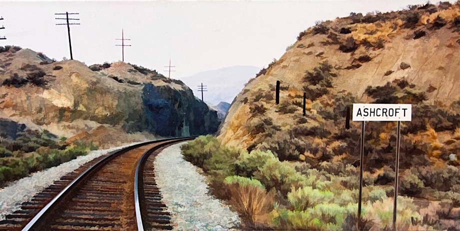
ASHCROFT (Mile 47.3): Ashcroft was the name given by brothers Clement and Francis Cornwall to their ranch and roadhouse
on the Cariboo Waggon Road in 1861, and comes from the name of their family home in Gloucestershire, England. With the
coming of CP in 1885, a town sprang up around the station and depot on the Thompson River, three miles east of the
Cornwalls' property. The Cornwalls had a post office named Ashcroft on their land, and the federal government moved the
post office, and its name, to the new town, to the Cornwall brothers' annoyance. Their property is now called Ashcroft
Manor, and their 1862 roadhouse still stands, one of the few remaining roadhouses on the Cariboo Road.
In part two, we will look at the meanings behind the names between Black Canyon and North Bend, as well as one place
just east of Kamloops whose sign is unique in CP's rail network.
Barbara Roden.


(likely no image with original article)
(usually because it's been seen before)
provisions in Section 29 of the
Canadian Copyright Modernization Act.

