
 40 Images
To view most of the photos with this article click on the camera above. For the rest scroll down the page.
|
|
|
Canada Line Construction
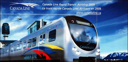
This image is displayed on several large signs located about greater Vancouver and also on a child's poster available for downloading from the Canada Line web site.
| |
 At a Glance At a Glance
Technology: Automated Light Metro
Length: 19.5 kilometres
Stations: 16
Estimated Riders: 100,000 daily
Water Crossings: 2 bridges 1 tunnel
Cost: $2 Billion approx.
Journey Time: 25 minutes
Frequency: Every 6 minutes
Builder/Operator: InTransitBC
|
|
The Canada Line is an urban transit rail line under construction in greater Vancouver, British Columbia, that was commenced on 1 Nov 2005. It is being built by InTransitBC, a joint venture company owned by SNC-Lavalin, the Investment Management Corporation of BC ( IMBC ), and the Caisse de Depot et Placements de Quebec. They have an agreement to operate the line for 35 years upon completion. SNC-Lavalin is responsible for the total engineering, procurement, and construction of the line.
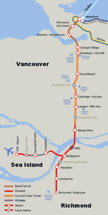
Once complete the Canada Line will connect Waterfront Station on Burrard Inlet with Vancouver's International Airport ( YVR ) on Sea Island and Richmond Center in Richmond, a total distance of 19.5 kilometres.
The route involves below ground tunnels, above ground elevated concrete guideways on pillars, plus three water crossings. Construction completion is estimated for 1 Jan 2009 in plenty of time before the start of the 2010 Winter Olympics.
The Canada Line Route
| | 
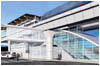
Waterfront.
|
Let's examine the Canada Line's route beginning at Waterfront Station on the shore of Burrard Inlet near the center of downtown Vancouver and travel south to the line's junction to YVR and Richmond city centre. Waterfront Station was constructed by the Canadian Pacific Railway in 1914 and was their third station built for a Vancouver terminus. A new upscale restaurant recently opened in the east wing of the station named "The TransContinental Heritage Restaurant & Railway Lounge".
Currently Waterfront Station is the hub for three transportation modes and when the Canada Line is complete it will be the fourth connection. From the station's great hall an entrance leads to the SkyTrain, West Coast Express, and the SeaBus. SkyTrain utilizes Bombardier proprietary Advanced Rapid Transit linear induction technology to propel the trains along two routes, the Expo and Millenium lines, through greater Vancouver. ( See the map located at the end of this article. ) West Coast Express trains use Bombardier built coaches pulled by conventional diesel-electric locomotives along trackage owned by Canadian Pacific from the station east to Mission City in weekday only service. The SeaBus is a passenger ferry plying the waters of Burrard Inlet between the station and North Vancouver across the inlet.
| | 
TBM.
|
The Canada Line route construction was, or will be, accomplished by tunneling with the use of a huge Tunnel Boring Machine ( TBM ), cut-and-cover tunnelling, an above ground concrete guideway raised on concrete pillars, and a small portion of trackage laid at grade. Commencing at Waterfront Station the bored tunnel beneath Cordova Street travels in a southwesterly direction towards Vancouver Center Station located beneath Granville Street. The tunnel then turns to the southeast to reach the third station on the route, known as Yaletown or Roundhouse Station.
| | 
Roundhouse.
|
The Roundhouse community center found here is comprised of Canadian Pacific's old Drake Street roundhouse, a heritage structure, with renovations and modern additions. It houses CPR steam locomotive Number 374, which pulled the first train to arrive in Vancouver from the east on 23 May 1887. The Roundhouse is located in the area of Vancouver known as Yaletown, hence the dual name for this Canada Line station.
| | 
Olympic.
|
The bored tunnel continues beneath False Creek, the first water crossing, to reach the Olympic Village Station currently under construction. From this point south to almost the Marine Drive Station all tunnelling was constructed with the cut-and-cover method. The route generally runs due south beneath Cambie Street where many retail stores and offices line the street until reaching Queen Elizabeth Park (Little Mountain, an extinct volcano) whereupon the area becomes more residential. Farther along this route lies Oakridge Shopping Center, Langara College, and Langara golf course. Construction on Cambie has raised the hackles of many retail store owners due to the disruption of their commerce. An attempt to obtain financial relief from the government for their problems has not met with success.
The photos of Langara Station show a good example of the "during" and "after" condition of Cambie Street. Prior to construction the street was four lanes with a grassed and treed boulevard between. After cut-and-cover tunnel construction the street will be returned to very near its original look except for the addition of Canada Line stations along the route.
| | 
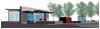
Marine Drive.
|
This brings us to the Marine Drive Station. As the trackage leaves the cut-and-cover tunnel it rises on the concrete elevated guideway in its approach to the crossing of the North Arm of the Fraser River on a cable stayed bridge. This type of bridge consists of one or more columns (normally referred to as towers or pylons), with cables supporting the weight of the bridge deck and the load the bridge is required to handle.
| | 
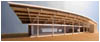
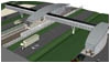
O&M Shop.
|
The Canada Line Operations and Maintenance Centre is located south of the North Arm in Richmond at Van Horne Way near Highway 99. The maintenance centre is a large building constructed with a structural steel framework. A substation building nearby will convert electricity to meet power requirements for Canada Line trains.
| | 
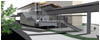
Bridgeport.
|
The next station along the route, and the first station to lie in Richmond, is Bridgeport. It's located next to a big casino complex known as the River Rock Casino Resort. A newspaper article from October 2006 reported the present casino produces four times the number of police calls compared to the old casino it replaced. The Bridgeport station, now under construction, lies across from the casino and surrounds the elevated guideway here.
| | 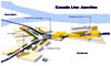
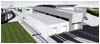
Junction.
|
Further to the west lies the only junction in the Canada Line. A very tall mass of criss-crossing concrete guideways that split the route into a junction with the westerly leg heading towards Sea Island and Vancouver International Airport (YVR) while the southerly leg heads south on the elevated guideway along Number 3 Road to the terminal, Brighouse Station, at Richmond City Centre.
| | 
Sea Island.
|
Taking the westerly leg from this elevated junction the elevated guideway crosses the Middle Arm of the Fraser River on a concrete bridge to reach Sea Island. The guideway drops to ground level upon leaving the Middle Arm Bridge, before reaching Templeton Station, and continuing to Sea Island Station at grade. Laying track at grade accommodates a future elevated aircraft taxiway over the line. Track then climbs up onto concrete pillars and guideway to reach the terminus at YVR Station.
Taking the southerly leg from the elevated junction leads to Aberdeen, Landsdowne, and the southernmost terminus of Brighouse at Richmond City centre.
Rolling Stock
| | 
Rotem vehicle.
|
The trains to be used on the Canada Line are NOT the same as the two SkyTrain lines so they aren't interchangeable. The SkyTrain transit vehicles were built by Bombardier and use their proprietary ART (Advanced Rapid Transit) linear induction technology to propel the vehicles. This requires power pick-up from two rails mounted vertically to the side and parallel with the standard gauge running rails. In addition, there is an aluminum clad flat steel plate known as the LIM rail positioned between the running rails.
The vehicles for the Canada Line trains are designed and built by the Rotem Company, a division of Hyundai Motor Group, in Changwon City, South Korea. Their transit vehicles utilize conventional traction motors powered by a covered third rail paralleling the standard running rails. This third rail is comprised of aluminum with a steel cap on the rail top to absorb the wear and tear of truck mounted contact shoes.
| | 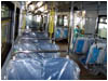
Vehicle interior.
|
The Rotem vehicles are 3 metres wide by 41 metres long by 3.6 metres high. There are 2 cars per train with a passenger capacity of 334 people per train. They weigh 76 tonnes empty and are capable of 80 kilometres per hour. This makes them wider and longer than the SkyTrain vehicles.
Rotem Transit Vehicle Features - Driverless operation;
- Stainless steel exteriors;
- Vandal-resistant finishing;
- Gangway connection between each pair of cars;
- Wheelchair, stroller, and bicycle accessible;
- Wide aisles;
- Air conditioning;
- Emergency passenger intercom panels;
- Emergency silent passenger alarm;
- Electronic interior next station signs;
- Electronic exterior destination signs;
- Public address system.
Video Clips
Video - TBM Tunnel Breakthrough ( Windows .wmv file )
Video - Rotem Vehicle Test South Korea ( Windows .wmv file )
Newspaper Stories
3 Aug 2005 - Final RAV Deal up by $180 Million
20 Feb 2006 - Alcatel Awarded Euro 25 Million Contract for Driverless Train Control System
2 Aug 2006 - Canada Line Construction
20 Oct 2006 - Richmond Casino is a Crime Magnet
20 Oct 2006 - Evergreen Line Too Expensive?
7 Apr 2007 - Canada Line Reaches Landmark Breakthrough
22 May 2007 - Minister's Asia Tour 2007
31 May 2007 - Schwarzenegger Comes to Vancouver
17 Jul 2007 - Canada Line: Going Deep Beneath the Surface
29 Aug 2007 - Tunnel Boring Crew Prepares to Arrive at Yaletown-Roundhouse Station
11 Sep 2007 - Canada Line Tunnelling Firm Denies Union's Pay Allegations
25 Sep 2007 - Error Delays Canada Line Construction
Editorial
While it's easy to criticize the construction and possible operating problems that may occur once the Canada Line is complete, there's one underlying fundamental criticism most seem to have missed.
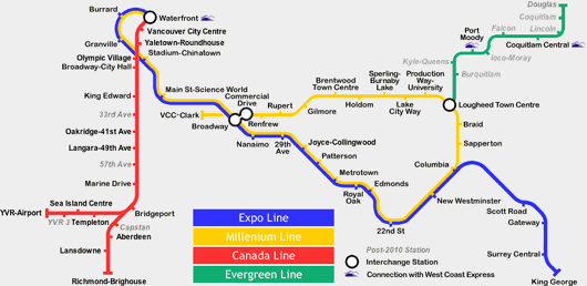
There are four rail transit lines shown on the map of Vancouver above, five if the West Coast Express route were added. Presently the Expo Line and the Millenium lines operate Bombardier's driverless proprietary Advanced Rapid Transit linear induction technology to propel trains. The Canada Line will NOT use Bombardier technology but the more common third-rail and electric traction motor propulsion. The Evergreen Line is expected to be constructed as a driver-operated Light Rail Transit line to some other different technology, perhaps using overhead catenary. Not shown on the map, is the West Coast Express using conventional diesel-electric locomotives for propulsion between Waterfront Station and Mission City, 68 kilometres to the east.
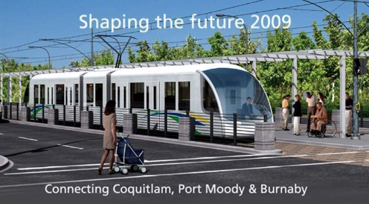
Artist's conception of an Evergreen Line Light Rapid Transit vehicle.
These four different rail technologies require four different types of rolling stock, propulsion, signalling systems, maintenance centres, and skill sets to operate and maintain. All to service what is really one overall rail transit system covering Greater Vancouver.
If Bombardier SkyTrain technology met expectations well enough on the Expo Line to permit the construction of a second line, the Millenium Line, why wasn't Bombardier technology chosen for the third line, the Canada Line? Are we penny wise and pound foolish? Will it cost much more in the long-term because of this choice? Why have we created four different rail transit technologies where there should be only one?
Mapping Software
MapSource is a mapping application sold by the Garmin Corporation. This article provides a downloadable file so you may locate photographs by their latitude and longitude co-ordinates with mapping software on your computer. You require the MapSource program installed on your computer for this file to be useable. If you own a Garmin vehicle GPS navigation system this file may be uploaded from MapSource directly into your vehicle GPS.
Associated Web Sites
Canada Line
Rotem
Bombardier
SNC-Lavalin
Alcatel - Lucent
Evergreen Line
West Coast Express
Translink
Do RAV Right
Downtown Historic Railway
Transit Museum Society - TRAMS
City of Vancouver
Vancouver International Airport
City of Richmond

|
|