


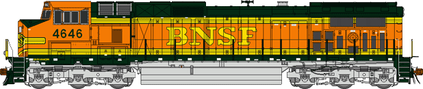
The background photograph with this article shows Burlington Northern Santa Fe number 4583 leading two other helper units eastbound through Tunnel Number 1 at Cajon Pass. This line was double-tracked by 2008 resulting in both Tunnel 1 and Tunnel 2 being removed or "daylighted".

From Barstow the railway leads northwest via Boron to Tehachapi Pass over the Tehachapi Mountains. Trains must negotiate stiff grades from the western side at Bakersfield with a starting elevation of 500 feet to Tehachapi with an elevation of nearly 4,000 feet.
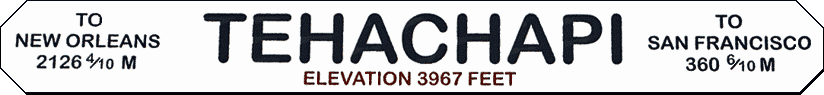
The renowned Tehachapi Loop and the horseshoe curves at Caliente (kal-ee-EN-tay) are along this route and offer an unparalleled opportunity for railway photos with dirt access roads and few trees blocking the view of trains. Long trains and slow speeds upgrade or down offer the possibility of catching many photos of the same train along this route.
ENGINEERING LANDMARK
In front of you is the world famous Tehachapi Loop which is about halfway upgrade to the Tehachapi Pass. This steep line averages 2.2% in gradient in its 28 miles of length. This feat of civil engineering genius was the crowning achievement of civil engineer William Hood of the Southern Pacific Railway Company. It is one of the seven wonders of the railroad world.
The Tehachapi Pass Railroad Line was cut through solid and decomposed granite by up to 3,000 Chinese laborers from Canton, China. They used picks, shovels, horse drawn carts, and blasting powder. This line, which climbs out of the San Joaquin Valley and through the Tehachapi Mountains had 18 tunnels, 10 bridges, and numerous water towers for the old steam locomotives. It was completed in less than 2 years time under the leadership of civil engineer J.B. Harris, Chief of Construction, a remarkable feat.
This line was part of the last and final link of the first railroad line connecting San Francisco to Los Angeles. It was a primary factor in the early growth of the City of Los Angeles and the State of California.
This single track line, essentially unchanged, is still in constant use today, 122 years after its completion. It passes an average of 36 freight trains each day. This attests to the superior job of both engineering and construction done by the two civil engineers and the Chinese laborers. This plaque is dedicated to them.
Los Angels Section and Southern San Joaquin Branch
American Society of Civil Engineers
The Los Angeles basin lies near the end of the southwest leg of this giant X. Greater Los Angeles is generally located at an elevation around 200 feet. Trains travelling towards Barstow must climb up to the Cajon (ka-HOAN) Pass at a summit of 3,800 feet before reaching the relative plateau of the Mojave Desert. From the summit of Cajon Pass shared BNSF and UP trackage descends towards Barstow.
The Union Pacific Railroad (UP) owns one track through the Pass which was new construction completed by the Southern Pacific Railroad (SP) in 1967. The UP having absorbed the SP in 1996. This line, which runs northwest from Cajon Pass across the western Mojave Desert to Palmdale then northward to a junction at Mojave with the BNSF and shared trackage over the Tehachapi Pass, is known as the Palmdale Cut-off.

The Burlington Northern Santa Fe Railway (BNSF) owns two other tracks through the Cajon Canyon from its takeover of the Atcheson Topeka & Santa Fe (ATSF) and the Santa Fe's subsidiary the California Southern that completed the first track through Cajon Pass in 1885. UP and BNSF share trackage rights through the pass ever since the UP takeover of the SP. The original ATSF track grade of 3 percent makes descent dangerous and there have been several runaways. A second track, built in 1913, is 2 miles longer to obtain a lower 2.2 percent grade. In 2008 BNSF began to operate a third main track in the pass. It once ran through two short tunnels just east of Alray but both were daylighted
 when this third main track was completed in 2008.
Cajon Incidents (from Wikipedia)
12 May 1989 - The steep downhill grade south of the pass was a contributing factor in the San Bernardino train disaster.
14 Dec 1994 - Cajon Pass was the site of a major accident when a westbound ATSF intermodal train lost control and crashed into the rear of a westbound UP coal train just below California Highway 138, between Alray and Cajon.
2 Feb 1996 - A conductor and brakemen were killed when a BNSF chemical train derailed and caught fire at Cajon Pass.
16 Aug 2016 - The Blue Cut Fire destroyed a trestle on the Union Pacific mainline.
21 Aug 2018 - A train carrying hazardous materials derailed, causing the FedEx facility on the left of it to evacuate, along with a school that took shelter.
Northeast of Barstow trackage runs across the desert to Las Vegas, in the state of Nevada. Tracks follow the Mojave River through colourful Afton Canyon along this route. Most of the year the river is a dry wash but has caused damage to the right-of-way in the past when reaching flood stage. The canyon is accessible by a gravel road that begs for a four wheel drive vehicle. Some fording of the Mojave River may be required. It is recommended you do NOT drive along any dry wash due to the risk of sudden unannounced flooding.
The leg southeast of Barstow leads to Needles then onto Arizona. This route was not explored so won't be discussed here.


