|
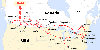 Map showing CPR lines and location of Field, British
Columbia.
Map showing CPR lines and location of Field, British
Columbia.
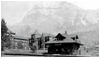 Mount Stephen House and the log station at Field in
1905.
Mount Stephen House and the log station at Field in
1905.
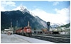 The current station and roundhouse in 1986.
 Field station in 2002 now used only for crew
changes.
Field station in 2002 now used only for crew
changes.
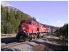
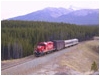
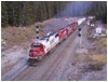
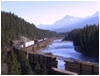
 CP 9650 East on the south track of the Lake Louise grade
separation at milepost 119.
CP 9650 East on the south track of the Lake Louise grade
separation at milepost 119.
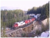
 CP 9136 West on the S curve by O'Hara Lake road
crossing.
CP 9136 West on the S curve by O'Hara Lake road
crossing.
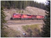
 CP 9136 West passes Field West signals and electric
derail.
CP 9136 West passes Field West signals and electric
derail.
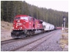
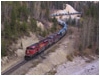 CP 9136 West in Kicking Horse Canyon near
Glenogle.
CP 9136 West in Kicking Horse Canyon near
Glenogle.
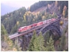
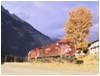 CP 9540 West passing the newly renovated Field
bunkhouse.
CP 9540 West passing the newly renovated Field
bunkhouse.
 Track Evaluation Car 21 westbound on north track between Lake
Louise and Divide.
Track Evaluation Car 21 westbound on north track between Lake
Louise and Divide.
 SOO 6004 West hauls 7,303 tons upgrade at
Divide.
SOO 6004 West hauls 7,303 tons upgrade at
Divide.
 SOO 6004 West crossing the Ottertail Creek
bridge.
SOO 6004 West crossing the Ottertail Creek
bridge.
 CP 9112 West doing the chicken at one mile per hour with 5,559
tons by Divide, eventually.
CP 9112 West doing the chicken at one mile per hour with 5,559
tons by Divide, eventually.
 CP 9160 West on north track.
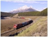
 CP 9512 East climbs the Big Hill.
 CP 9512 East at Morant's Curve.
 Except for a gon full of scrap wheels, an empty eastbound
coal train crosses Stoney Creek bridge.
Except for a gon full of scrap wheels, an empty eastbound
coal train crosses Stoney Creek bridge.
 Enter latitude and longitude coordinates in map software to
locate where a photo was taken.
Enter latitude and longitude coordinates in map software to
locate where a photo was taken.
|
|
A Field
Trip
 Field, British Columbia, lies in Yoho
National Park at the heart of the Rocky Mountains. Field is the crew change point
between the Canadian Pacific Railway's Mountain and Laggan Subdivisions. Field, British Columbia, lies in Yoho
National Park at the heart of the Rocky Mountains. Field is the crew change point
between the Canadian Pacific Railway's Mountain and Laggan Subdivisions.
Running trade employees typically work the Laggan Sub from Calgary to Field where
they layover for rest before returning to Calgary. For the Mountain Sub it's
Revelstoke to Field and back. At this time, October 2002, the Field bunkhouse is
receiving a makeover so crews sleep at the Lodge in Field or up the "Big
Hill" at Wapta Lake Lodge.
 Welcome to Field
Field is a small community, crowded with tourists during the summer, but
hibernates through the winter under a healthy snow cover. Meals may be obtained
at the beanery attached to the bunkhouse or for a change of pace there's the
"Truffle Pigs Cafe and General Store" located in the center of town. I
would estimate Field is comprised of perhaps a hundred homes including a post
office, school, lodge, and the CPR bunkhouse. The townsite lies within Yoho
National Park on the south side of the Kicking Horse River sandwiched between
the river and Mount Stephen. Town expansion east or west is blocked on all sides
by either the river, mountain, or an avalanche path.
Rail Traffic
Trains generally pass through in both directions but are sometimes
"staged", or temporarily stored, in the yard for several hours until
they can be forwarded. Westbound trains will tie down their cars and
cut-off their power which runs back to the station for a crew
change. The process is reversed for departing westbounds.
Stack trains, solid container trains, grain trains, or mixed freight including
tankcars, gons of scrap steel, boxcars, or even flatcars with hydro poles appear
in no apparent order.
Time Zones
For the railway, Field marks the time zone change between Pacific Time, on the
west, and Mountain Time on the east. Just to confuse you further, Pacific Time is
used on the Mountain Sub, west of Field, and Mountain Time is used on the Laggan
Sub, east of Field, while the townsfolk seem to use Pacific Time, which changes to
Mountain Time on the other side of the mountain. So, if you can't tell what time
it is, you're normal.
Mountain Subdivision
CPR's Mountain Sub runs west from Field 125.7 miles to Revelstoke. Prominent
settlements include Field, Golden, and Revelstoke, the rest holds some pretty
spectacular railway engineering. This includes the famous Rogers Pass tunnels,
Connaught, MacDonald, and Shaughnessy with it's associated viaduct, and don't
forget Stoney Creek, Mountain Creek, and Surprise Creek bridges. Just west of
Golden lies KC Junction, the connection to the Windermere Sub which runs south
to British Columbia's coal mines and the source of all those coal carrying unit
trains visible all the way to Pacific tidewater.
Laggan Subdivision
From Field the Laggan Sub runs east 136.6 miles to Calgary, Alberta. Calgary is
one of the province's two largest cities. Major towns east of Field include Lake
Louise, Banff, Canmore, and Cochrane located on the Trans-Canada
Highway. Trains departing Field immediately encounter the "Big Hill",
a 2.2 percent grade eased from the original 4.5 percent grade by construction of
the Spiral Tunnels in 1909. The Trans-Canada Highway was built on
the original grade for most of its route up the hill and gives one a clear
understanding of the steepness. It's hard to imagine how steam engines could
struggle up this steep incline aptly named the "Big Hill".
Between Divide and Lake Louise the track splits into two roughly parallel tracks
separated in elevation. The north track was added in 1978 to ease the climb to
Stephen from Lake Louise. Just east of Lake Louise lies Morant's Curve named
after CPR's famous photographer, Nicholas Morant. Banff National Park and the
other towns are located east of this.
Sunday, 20 October 2002
The day started with a drive to Lake Louise. While making breakfast the scanner
went off at milepost 111.0 announcing the presence of a train. This was 5.2 miles
east of my position so I knew the train would arrive shortly. However the
detector reported one bad axle so the crew radioed the RTC (Rail Traffic
Controller). He requested an advisory when they started again. The train passed
me about twenty minutes later at Lake Louise but the light was too dim
for a decent photo.
As the rising sun began to brighten the snow covered mountain tops I headed west
where the Lake Louise grade separation is clearly visible from the
Trans-Canada Highway. Pulling clear of the highway CPR milepost
119 offered a view of both the north and south tracks with gorgeous scenery as
a backdrop. The air was crisp and clear. It was a perfect shot as an
eastbound bomb train with mixed freight pulled into my viewfinder.
A few miles to the west lies the turn-off to O'Hara Lake and a
grade crossing. A short wait there and 9136 West rounded the "S"
curve into my sights.
Following this train west, after a crew change at Field, another photo caught the
train at Field West signals beside the electric derail.
Now running in the Pacific Time Zone the train continued past Ottertail,
Leanchoil, Palliser, and into the steep sided Kicking Horse River Canyon just
east of Golden. By this time the sun had disappeared but one photo caught the
train curving through the canyon. This being the Rockies the weather continued
to change throughout the rest of the day with the sun popping out now and then
between very brief rain showers.
The day ended well at Field when the sun poked through a grey cloud cover and
9540 West arrived passing the bunkhouse which is currently under renovation.
By midnight all the stars were out and it was cold and clear for 360 degrees. The
next day would be promising.
Monday, 21 October 2002
In the morning there wasn't a cloud in sight, until... driving up the "Big
Hill" when high cloud cover moved in from the north. There were still a
few holes where the sun poked through so hope wasn't entirely lost. Setting up
the camera tripod on the north track east of Divide, the first train of the day
was anticipated, TEC 21. This is CPR's custom built Track Evaluation Car with a
crew car, and support boxcar, pulled by GP-9 number 8218. Camera light alternated
dark and light but was just bright enough as TEC 21 passed by westbound.
The camera position was next moved west to milepost 121.5 at Divide. Divide marks
the west end of the Lake Louise grade separation where the north and south tracks
funnel into parallel tracks until reaching Stephen 1.6 miles west. A shot from
the Trans-Canada Highway overpass caught SOO 6004 West climbing the
grade.
Chasing this train west I bypassed Field with Ottertail as the target. After a
short wait SOO 6004 West was snapped crossing Ottertail bridge 8.2 miles from
Field.
With the sun now shining brightly a return trip to Field was in order for lunch
at the Truffle Pigs. A combination grocery store, restaurant, liquor store, gift
shop, and full of oddities. There was an old worn-out 1930s ice
skate on one table, for decoration I guess.
 After a good lunch the scanner picked up a conversation between the RTC and a
maintenance of way foreman requesting a T.O.P. (Track Occupancy Permit). This
would be delayed as a westbound train was climbing the north track at one mile
per hour. What? That's correct, ONE mile per hour! The foreman would have to
wait. A race up the Big Hill to Divide beat the train there. Sure enough, one
mile per hour. Why rush? You can walk faster than this. With all sanders flowing,
4,300 horsepower dragging 5,559 tons behind, SD90MAC number 9112 bounced up and
down nearly as much as it progressed forward. Railway men call this "doing
the chicken". Personally, I think the hogger and shack should get flight
pay for this sort of ride.
After a good lunch the scanner picked up a conversation between the RTC and a
maintenance of way foreman requesting a T.O.P. (Track Occupancy Permit). This
would be delayed as a westbound train was climbing the north track at one mile
per hour. What? That's correct, ONE mile per hour! The foreman would have to
wait. A race up the Big Hill to Divide beat the train there. Sure enough, one
mile per hour. Why rush? You can walk faster than this. With all sanders flowing,
4,300 horsepower dragging 5,559 tons behind, SD90MAC number 9112 bounced up and
down nearly as much as it progressed forward. Railway men call this "doing
the chicken". Personally, I think the hogger and shack should get flight
pay for this sort of ride.
Tuesday, 22 October 2002
Tuesday dawned cold and crisp with a light frost covering everything in sight.
The weather was more sunny than grey but always seemed to be grey when the
shutter release was pressed. Trains were fewer this day for some reason. Perhaps
this was CPR's "Two Train Tuesday"?
Much driving back and forth during the day yielded only three decent photos.
CP 9160 West and buddy were photographed just east of Divide as they passed by
under dull sky. The Big Hill was mostly in shade and still frosty by early
afternoon but 9512 East was shot exiting the Big Hill's small tunnel. By the time
it had reached Morant's Curve the sun was out in full force producing a pleasant
temperature. A final return to Field ended all photography for the day.
Reference
An N scale drawing of Field station may be found on page 44 of the March 1996
issue of Mainline Modeler magazine under the title "Canadian Pacific
Station; Field, British Columbia" by Patrick Lawson.
Associated Links
Canadian Pacific Railway
Village of Field
Yoho National Park
Mainline Modeler magazine
Bears
©
2002 William C. Slim
http://www.okthepk.ca
|
|
|