Mapping
Software
The Software
 Streets & Trips is a mapping application
sold by the Microsoft Corporation. It contains a large map of the United States
and Canada showing, landmarks such as mountains, rivers, lakes, railways lines
and roads. It features a route planner to find and schedule stops, set route and
driving preferences, plus calculate and optimize a driving route. It also contains
a search function whereby you may search for cities, airports, businesses,
attractions, and other points of interest including any point on the map
specified by latitude and longitude. Streets & Trips is a mapping application
sold by the Microsoft Corporation. It contains a large map of the United States
and Canada showing, landmarks such as mountains, rivers, lakes, railways lines
and roads. It features a route planner to find and schedule stops, set route and
driving preferences, plus calculate and optimize a driving route. It also contains
a search function whereby you may search for cities, airports, businesses,
attractions, and other points of interest including any point on the map
specified by latitude and longitude.
How to Use it Here
When you enlarge any photograph in this article you will find located beneath each
photo the coordinates (Latitude and Longitude) for that particular photo along
with the bearing. If you have Microsoft's Streets & Trips application
installed on your computer you may copy these coordinates into the Find Nearby
Places dialog box and the location where the photo was taken will be shown on the
map. The bearing shown with the photo indicates the approximate direction the
camera was facing for the shot. (000 degrees is North, 090 is East, 180 South, and
270 West.) A GPS (Global Positioning System) receiver should have been used to
obtain coordinates, but in this case, only an approximate location is supplied.
GPS Receivers
GPS receivers take in data from the Global Positioning System, a group of 24
satellites orbiting the Earth. The 24 satellites that make up the GPS space
segment orbit the earth at about 12,000 miles. They are constantly moving, making
two complete orbits in less than 24 hours. These satellites are travelling at
speeds of roughly 7,000 miles an hour. GPS satellites are powered by solar energy.
They have backup batteries onboard to keep them running in the event of a solar
eclipse, when there's no solar power. Small rocket boosters on each satellite keep
them flying in the correct path. The satellites were developed and launched by the
United States Department of Defense at a cost of more than $12 billion. This
system is the most advanced navigational technology ever developed. It can
provide precise latitude, longitude, bearing, altitude, time, sunrise, sunset,
plus speed and direction to a moving receiver anywhere on Earth, in any weather,
at any time. There are no subscription fees or setup charges to use GPS.
There are some limitations to the Global Positioning System. All civilian GPS
receivers are subject to degradation of position and velocity because of
Selective Availability (S/A), an operational mode imposed by the American
Department of Defense that degrades civilian signals for security purposes.
Consequently, the accuracy of civilian GPS receivers may be degraded by up to 100
meters (330 feet). SA was intended to prevent military adversaries from using the
highly accurate GPS signals. The government turned off SA in May 2000, which
improved the accuracy of civilian GPS receivers. GPS receivers equipped with WAAS
(Wide Area Augmentation System) capability can improve accuracy to less than 3
meters on average. Also, because a GPS receiver must track data from at least
three satellites at once, it must have a direct line of sight to the sky when
used.
To work with Streets & Trips, a GPS receiver must be compliant with NMEA
(National Marine Electronics Association) standards, and its input/output format
(interface) must be set to support NMEA 0183 version 2.0 or later.
Photo Location Accuracy
Although GPS receivers are available in Canada for as low as $199 dollars I don't
have one as yet. Consequently, the latitude and longitude coordinates given with
each photo are approximations derived from the Streets & Trips software. The
coordinates are NOT accurate to within 3 meters. However, using this software
and my coordinates you should be able to easily drive within walking distance of each
photo location.
Streets & Trips is mainly intended for route planning so the road maps are
reasonably accurate. However, when it comes to railways the software displays some
glaring errors and is not reliable. Natural landmarks such as rivers are shown in
some cases but disappear when you zoom the map. The coordinates supplied were
obtained from Streets & Trips 2001. They have not been tried on any other
version of the software. Hopefully later versions of this product will contain
less errors. For now, the road map display is workable.
Entering Coordinates in Streets & Trips
- You will use your mouse to highlight first the Latitude coordinate and then
return to highlight the longitude coordinate displayed beneath a photo. Exclude
letters and include numbers plus any minus signs. For example, using the longitude
value W -117.4370, highlight only the blue
portion ignoring the W.
(With latitude coordinates, positive
numbers indicate North, negative numbers are South. With longitude, positive
numbers indicate East, negative numbers West.)
- Press both the "Ctrl" and "C" keys to copy
the value into memory.
- Transfer to the Streets & Trips program then press the Find button
located on the topmost menu to display the following dialog
box.
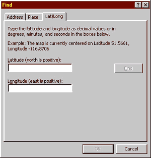
- Paste the latitude coordinate into the latitude field then return to the
photograph to copy the longitude value. Come back to Streets & Trips then
paste that value into the longitude field.
- Now that the coordinates are copied into the Street & Trips dialog box
fields press the "Find" button just to the right. Streets & Tips
will then place a marker on the map in the location where the photo was taken.
Click the OK button and the position will be labeled.
Associated Links
Microsoft Streets &
Trips
Garmin GPS Products
National Marine Electronics
Association
©
2002 William C. Slim
http://www.okthepk.ca
|