


Shortly after the close of Expo 86 , Vancouver's world fair to celebrate the centennial of its founding as a city, a retired railway archivist
wrote a cautionary note about No. 374, the rebuilt locomotive that was one of the most popular displays during the exposition. This engine had led
the first official train of the Canadian Pacific Railway Company (CPR) along its twenty-kilometre extension from Port Moody, the original Pacific
terminus of the railway, into Vancouver on 23 May 1887. The archivist understood how markedly cosmetic restoration had changed the historical
artefact, and he remarked wryly that much of what had been written about the refurbished locomotive was "so much
'bumph"1.
, Vancouver's world fair to celebrate the centennial of its founding as a city, a retired railway archivist
wrote a cautionary note about No. 374, the rebuilt locomotive that was one of the most popular displays during the exposition. This engine had led
the first official train of the Canadian Pacific Railway Company (CPR) along its twenty-kilometre extension from Port Moody, the original Pacific
terminus of the railway, into Vancouver on 23 May 1887. The archivist understood how markedly cosmetic restoration had changed the historical
artefact, and he remarked wryly that much of what had been written about the refurbished locomotive was "so much
'bumph"1.
This article suggests much the same about the interpretation of events that made the artefact significant. For more than a century most accounts
of CPR activities during the "interesting phase" that preceded the arrival of No. 3742 have accepted the view of pioneer realtor A.W. Ross, self-proclaimed agent of the railway company3, that the
"far-seeing and energetic management of the CPR" was extraordinarily successful in the initial phase of terminus development at Vancouver 4. This consensus stems in large part from the CPR's tight control of information. Its reluctance to release detailed accounting
data has led historians to assume rather than to demonstrate the profitability of elements of railway terminus development for this period, such as
real estate manipulation and trans-Pacific shipping5.
The company's retention of most of its archival documents has also greatly limited accessible sources on which to build an interpretation6. Besides the local newspapers, the only acknowledged source for railway activity concerning the new terminus
was an edited correspondence with the CPR that the provincial government had published to bolster its case for transferring tracts of terminus land to
the company7. But the CPR actions detailed therein were of less interest to contemporaries than were those of
several members of the Cabinet who were denounced as part of the "Coal Harbour Ring," speculators who benefited privately from the new
location of the terminus8. Only a generation later did a historian use the documents to conclude that the
province's grant represented a windfall for the company, the CPR had secured land to cover the cost of an extension that it would have had to build in
any case9.
During the 1930s, Major J.S. Matthews, the city's controversial first archivist, unabashedly supported Ross's sunny view of the CPR managers. Gathering accounts from
some of those who witnessed the arrival of No. 374 and their descendents, Matthews fashioned a grand celebration, a partisan heritage, of CPR
actions in Vancouver in which the city's "multitude, bow(ed), acknowledgement to that great corporate body, the Canadian Pacific Railway, without
which Canada could not have been"10. The hero/saviour of this epic was CPR
vice-president and general manager W.C. Van Horne, who, Matthews contended, not only located but also named the city. Suspect evidence in many
documents that Matthews collected and created as well as the archivist's assumption that the company acted from nobility as much as from self-interest
led most historians to dismiss his work11. But the most popular history of the
railway deploys Matthews's "Great Man" to offer another view of the BC government's published documents. Pierre Berton contends that, though
Van Horne lost a poker game to Vancouver sharps, the general manager's tough bargaining with the provincial government and local landowners made the
company "the real winner in a much more important game of skill and bluff", Pacific terminus acquisition and entry12.
Recent urban studies have been more critical of railway company terminus activities. But the standard academic account of the CPR entry follows
these limited documents, almost without question, to present a company that methodically located and developed a terminus to maximize the value of the
parcels it had obtained13. Such a view suggests what historian A.D. Chandler Jr.,
called "system building", the rational direction of trans-continentals by career executives during the last two decades of the nineteenth
century14.
Ironically, Matthews's ongoing enthusiasm for the CPR played a role in the release of additional important documents. In 1945, the archivist had
persuaded the railway company to rehabilitate and to donate locomotive No. 374 to the city in a melodramatic
recreation of the first arrival, complete with replica arches, insignia, and
flags15. In 1986, to commemorate not only the centennial of the city but also the
restoration for Expo of the engine that Matthews had procured, the CPR deposited in the city archives photocopies of several of Van Horne's files
concerning the creation of the terminus16. This deposit represented a significant
new source. More important, it provided leads to other correspondence in the CPR Archives in Montreal, to which the company intermittently granted
access.
(Following the second grand arrival of No. 374 in Vancouver for presentation to the city the locomotive was loaded onto a flatbed truck and
transported to Kitsilano for display
there.)
This study draws on these sources, as well as on scattered provincial, Dominion, and Imperial government records, to review three elements of the
railway's entry into Vancouver: (1) the company's initial terminus project west of the final location, (2) its dubious acquisition of the right to
expropriate an Indian reserve along its urban right-of-way, and (3) its protracted conflict with disappointed investors in Port Moody. Rather than
confirming a tale of corporate foresight and shrewdness, this investigation reveals that the CPR entry into its terminus was informed by error and
confusion, much as were the entries of other trans-continentals.
The received interpretation has it that Van Horne "decided on (the) more advantageous location" of the present site of Vancouver only
when he inspected Burrard Inlet in the summer of 1884 in a search for an alternative to Port Moody, the designated Pacific terminus at the head of the
inlet, now suddenly perceived as inadequate17. A review of the correspondence of
company officers and politicians suggests, however, that the Canadian Pacific had settled on Coal Harbour, some nineteen kilometres closer to the sea,
early in 1882 after a company engineer inspected and made an unfavourable report on Port Moody18. Alongside engineering considerations, however, financial necessity also forced the company to locate its terminus
elsewhere. While negotiating with the provincial government for an alternative site, the general manager admitted to an agent that the company
"had not one dollar to invest in real estate. The only question to be settled is how much land they (the government) are prepared to give to the
Co. on condition that this line shall be extended to Coal Harbour"19.
Coal Harbour, east of the peninsular military reserve that would become modern Stanley Park, was likely the initial alternative terminus, but the
general manager ensured that the company did not immediately commit to locate there. In 1880, the province first attempted to convey to the Dominion
government a 64 kilometre (40 mile) wide corridor of land that bracketed a hypothetical line from English Bay to the Alberta border as compensation
for the construction of the trans-continental railway20. Since the CPR's 1881
contract designated Port Moody as the terminus, Van Horne was anxious to acquire the corridor west of that site to which the Dominion would ultimately
have no claim. In June 1882, the company obtained a promise from Prime Minister John A. Macdonald that his government would "not part with any of its railway lands on the
Pacific Coast west of the Pitt River until the location of the terminus of the CPR was finally settled"21.
In January 1884, however, as part of the Settlement Act that resolved long-standing disputes concerning railway matters with British Columbia, the
Dominion government announced its intention to return the designated railway corridor west of Port Moody to the province instead of conveying it to
the company as Van Horne had hoped22. Consequently, the general manager needed
a pretext to justify quick intervention. He had been informed that the CPR Pacific Division resident engineer, Marcus Smith, was anxious to invest his savings at Coal
Harbour23. Rather than reveal that the company had for the past two years been
manoeuvering to extend its line beyond Port Moody, he asked Smith for a quick report on the terminus sites on Burrard Inlet. After dutifully
rehearsing the engineering shortcomings of Port Moody, Smith maintained that the largest uninterrupted block of government land lay on the south shore
of English Bay, west of Coal Harbour and the military reserve, and that it offered returns that would cover the cost of both the extension and the
terminal works24 (see Figure 1 below).

In early August, Van Horne inspected Burrard Inlet in the company of BC premier William Smithe, and he displayed to New Westminster city councillors a chart showing a line
from Pitt River to Coal Harbour that probably reflected the CPR terminus plan at the time. But he also examined the "very elaborate plan" of
the promoters of New Liverpool (a parcel that would become part of the modern West End of Vancouver), "upon which are displayed docks of all
kinds, a great breakwater, and wharves" jutting into English Bay25.
In September, the railway company requested 4,450 hectares from the provincial government as compensation for extending the line from Port Moody. The location of parcels in the plan that the company enclosed with the request suggests that Van Horne's terminus choice was the Granville tract since most of the requested tracts fronted Coal Harbour. The general manager indicated to the premier privately that he would settle for much less26. When the CPR accepted a provincial offer of 2,540 hectares in two tracts, Van Horne was clearly pleased. During the negotiations he had exchanged the northern half of the Hastings tract, a large parcel of land on the eastern approach that the government was prepared to grant, for the entire Granville tract, a smaller tract that centred on Coal Harbour and also allowed the railway to reach its land fronting English Bay without interruption. (See Figure 1.) Van Horne later reminded his superintendent of the importance of the premier's friendship and instructed him "to do anything we can in his private interest," which included selling company property at a discount27.
Unfortunately, at Coal Harbour, much of the return from selling lots near the terminal works would go to the private owners of three parcels that bracketed the Granville tract. At English Bay, on the other hand, as Smith had observed, only one small parcel, Lot 192, was apparently beyond the CPR's grasp, and the railway company attempted to intimidate its owners into making a significant donation for the terminus28. West of this lay the key parcel, apparently a large naval reserve allotted by the colony in 1860 before it entered Confederation but that had not been utilized by the Admiralty. The original naval tracing forwarded to the colonial government lacked post locations and chain lengths for a parcel labelled as a "proposed government reserve (of) 155 acres (63 hectares)" surrounding a cove that gave its name to modern-day Jericho29. In 1863, the colony set out with posts and chains a much larger government reserve behind the original parcel in the naval tracing. Since the colony did not monitor the designation and description of reserves carefully, the boundaries of the naval reserve were only crudely sketched inside the new government reserve in the field notes of the surveyor, it conflated (combined) the two parcels30. In 1868, the colony granted a timber lease for both parcels, now described as the "section of land set apart as the Naval Reserve at English Bay." Later, the provincial Department of Lands referred to it sporadically as a naval reserve that comprised 319 hectares31.
More important, however, was the incorporation of the colony's error in the authoritative British document on the matter, a detailed report
prepared in Victoria in 1881 on the military value of reserve lands in British Columbia. Though the report's authors, a royal engineer and a naval
commander, noted the inadequacies of provincial records, they nonetheless drew on them in designating the enlarged parcel as a naval
reserve32. From the plan that accompanied the 1881 report, the Admiralty
created, three years later, a rough sketch of prospective naval sites along Burrard Inlet that repeated the error. This sketch was acquired by the
company, probably in the fall of 188433. "Cartographic carelessness"
led Van Horne to accept its dubious evidence, and the company later elevated the sketch, which lacks scale, direction, and precise boundaries, into an
"exact tracing"34. Such single-mindedness also allowed the general
manager to ignore the province's precise location and designation of the enlarged parcel as a government reserve, with no reference to a naval
reserve, on the very plan that authorized its grant of tracts to the company!35
In his instructions for the survey of a new line to the site in December 1884, Van Horne revealed that his preferred terminus would ultimately front
the south shore of English Bay: "We want to build up the town on the large tract fronting on English Bay by locating our station, engine house,
etc., and terminal yards alongside of False Creek so that they can be extended eventually by filling that portion of it indicated in pencil and which
we expect to acquire"36.
In locating the terminus line, Major A.B. Rogers, the engineer whom the general manager esteemed for his location of the key pass that bears his name in the trans-continental
route, surpassed even Smith in his praise of English Bay. While Coal Harbour offered a location for a small initial dock, sand bars, which limited the
accommodation of heavy draft ships, made it unsuitable for a permanent terminus. The engineer continued: "The best situation for docks will be in
English Bay. This could be readily utilized by a float running from the shore northerly into the inlet and breaking the swell, so that ships can lie
at wharves without injury"37. Drawn with these assumptions, Rogers's
terminus plan displayed a geometrically straight main line that bypassed Coal Harbour, swept across the entrance of False Creek (which would be
filled), and terminated just beyond the southwestern corner of the alleged naval reserve whose designation, size, and location followed the Admiralty
sketch (see Figure 1). On the reserve a CPR draftsman printed "Proposed terminal and train yards." In the covering letter, Van Horne
declared that "English Bay must be utilized as the main harbour and the railway must be extended to run along English Bay." The acquisition
of the naval reserve was therefore "almost essential for the construction of proper facilities"38. This conclusion drove CPR plans for terminus location during the next eighteen months.
The CPR first requested the reserve from the Canadian government, apparently because it was informed that Britain had transferred title of this parcel in 1884 to the Dominion as one of a series of unoccupied naval and military reserves in British Columbia39. The government deflected the company demand by claiming that a later Admiralty request, prompted by a naval report of the CPR's relocating its terminus at English Bay, to "resume" possession of this reserve negated the British transfer40. However, by July the company had persuaded the Dominion to support a CPR request to the Admiralty for the parcel, probably by foregoing a second request for a portion of the military reserve (Stanley Park) at the end of its proposed secondary line at Coal Harbour (see Figure 1)41. Two months later, when presented with the CPR elaboration of its own rough sketch, the Admiralty turned to its authoritative report on the matter. It then displayed its own cartographic carelessness with a tentative offer to transfer all but forty hectares, that is, 278 hectares of the alleged reserve, to the railway company in exchange for only a railway spur and coaling wharf, facilities that the company would construct in any case in order to draw returns from servicing a naval base42. News of the CPR's planned English Bay terminus reached British Columbia and prompted two responses. The project clearly alarmed owners of lots that bracketed Coal Harbour. Henry Beatty, the CPR plenipotentiary in British Columbia, had carefully eliminated from all proposed agreements "everything & anything... implying any obligation to do anything in this direction (of locating at Coal Harbour)." He predicted to Van Horne that, "should you select English Bay, ...these (private lot owners) will come to their senses before long and will put in their property on almost any terms that you may desire"43. In a desperate attempt to entice the CPR away from English Bay, property owner I.W. Powell made the following offer in June:
If the syndicate... has any idea of utilizing Coal Harbour... I would like to make a proposition to secure for them all the lands and frontage there they require. Should the company be willing to agree to construct and maintain even a portion of their dock system and include the Granville Peninsula in their townsite, the property owners would donate the frontage and a third of their holdings. If the Co. would adopt it as their final terminus, the frontage and half of their land would be gladly given44.That Van Horne entered into agreements in September 1885 with the property holders in lots 185, 196, and 181, in which they donated only one-third of their holdings to the CPR, that is, that he rejected the immediate donation to a cash-starved company of additional real estate on Coal Harbour to preserve the CPR's freedom of action on English Bay, demonstrates his belief that English Bay would become the focus of the company's terminal works and, ultimately, of the city45.
Smithe, commissioner of lands as well as premier, had informed Beatty in early 1885 that the colony had allotted only some forty-eight hectares, less than one-fifth of the parcel that Van Horne expected, as a naval reserve, but the general manager ignored the warning46.
On the same day that the CPR revealed its terminus plan to the Dominion government, it suggested to the province an exchange of its property in the south end of the False Creek tract, still in the process of being conveyed, for provincial land west and south of the alleged naval reserve. Beatty later explained that the company required 1,214 additional hectares south of the alleged reserve "for shunting purposes," which would entail an exchange of almost half the original grant, hectare for hectare. Receiving no immediate reply, the CPR's BC solicitor threatened to withhold the executed agreement for the original provincial grant until he obtained information on the government's "formally agreeing to convey (the additional parcel)." This prompted the premier to observe that any new exchange must be value for value and that "it is expected the CPR must carry out its part... in good faith"47. However, during its successful drive to secure even more generous terms from the Admiralty in the fall, the company made no further attempt to justify or to explain to the province its request for the exchange. To demonstrate its title, the province resurveyed the government reserve and then sold the eastern portion of the parcel at public auction in January 188648.
Though CPR officers in British Columbia must have informed headquarters of the pending sale, which was widely advertised, the company did not respond until after the sale occurred. After declaring that "the Imperial Government had agreed to transfer the greater part of the (enlarged) reserve," the company maintained that no official document authorized or supported the government's claim concerning the reduced naval reserve. This position led Smithe to respond flatly that "there (was) not and never had been a naval reserve of 788 acres (319 hectares) at English Bay" and to copy correspondence that supported the same. In addition, the province maintained that a reserve held by British Columbia for the Admiralty could not be transferred again49.
Confronted with this blunt declaration, the CPR now described the Admiralty sketch as a "copy of the original tracing" and doggedly maintained that the government documents were erroneous. It threatened legal remedies to recover possession of the land that the province had sold50. But, in an urgent private letter to the Colonial Office, the Canadian high commissioner in London requested an immediate search of its records as well as those of the Admiralty and War Office for documents "either in the shape of maps, tracings, or letters" that confirmed the CPR claims. After belatedly locating and transmitting a copy of the 1860 tracing, the Admiralty declared that, since it no longer had a claim to more than sixty-three hectares, it could not transfer any land to the railway company51.
The company responded that the Admiralty had been "misinformed." Like the "doubtful" maps of the provincial government, this
British copy also rested on "information furnished by the Government of BC (only) after that government had determined to assume the position
that the reserve contained only 155 acres (63 hectares)." This malign influence made the newly discovered tracings suspect since they
"conflict(ed) directly with other official plans of the same property which had been issued by the government." However, since attempts by
CPR agents to peruse these other plans were "intentionally obstructed," the company was reduced to rehearsing the oft-cited references
published in the sessional papers52.
These accusations prompted a definitive response from the Admiralty. The 1860 tracing was compared to the original survey of 1859, and the reserve
plotted on each coincided. The Admiralty sidestepped its own role in the matter by referring to correspondence from the commander at Esquimalt, who
maintained that documents cited by the company contained the original error produced by the conflation (combining) of the provincial government and
naval reserves53. When Joseph Trutch, the Dominion agent in British Columbia and commissioner of lands during the
colonial era, confirmed the error, George Stephen, the CPR president, lamented, "all our efforts to induce the Admiralty to take our view have collapsed"54.
In Victoria in August 1886, Van Horne effectively conceded that the company's original design could not be implemented. He declared that the CPR would now "abandon English Bay and concentrate all (its) works on the Peninsula (fronting Coal Harbour)." A few months later, the company's agreement to remove its shops and yards from south of False Creek to the Granville tract for tax exemptions from the city clearly signalled the end of the project55. With the collapse of the CPR claim to the fictitious enlarged naval reserve went the grand plan for locating the terminal works at English Bay.
Historians and anthropologists have begun to make a critical examination of the role of railway companies in the alienation of Aboriginal land on both sides of the border56. What was once celebrated is now more frequently examined as ground for Aboriginal compensation. The CPR's acquisition of two small parcels in Kitsilano Indian Reserve No. 6, located south of False Creek, has been a part of complex litigation. But the company's attempts to expropriate the entire reserve of 32.4 hectares (80 acres) did more to "unsettle" the reserve than the most recent account acknowledges. These activities also provide a detailed illustration of what the court described as "procedural ingenuity," and of what others have viewed as corruption, in dealing with regulatory regimes57.
Although both the Railway Act and the Indian Act required that bands be compensated for railway expropriation of land on Indian reserves, the CPR escaped these provisions in the acquisition of right-of-way through reserves on its main line in British Columbia. Relying on a provision of its contract that made extinguishment of title on Indian reserves a government responsibility, the CPR dealt exclusively with the Department of Railways and Canals in this matter58. And, because the company regarded Indian reserves as private land, expropriation for right-of-way required only the railway minister's certification of route plans and books of reference. Compensation through valuation by the company or arbitration was settled later, as it was for other private landholders59. The railway department satisfied the compensation provisions of the two acts concerning Indian reserves by forwarding to the Department of Indian Affairs (dia) copies of the relevant company documents and notification of the valuation, which was invariably accepted. In a discussion concerning the appraisal of rights-of-way through thirty reserves between Port Moody and Savona's Ferry, a dia official admitted that an independent valuation would require inspection of each reserve, "which would occupy a long time." Even if this were undertaken, the official "decision would (not) differ materially from that of the sworn Commissioners, whose valuation has been accepted generally as equitable"60. Joseph Trutch, apparently the only commissioner who was not a railway company surveyor, had long been unsympathetic to Aboriginal claims concerning land and increased only one of the thirty valuations61.
When the BC government informed Van Horne that one parcel in the company's initial demand for terminus land comprised an entire Indian reserve, he realized that some negotiations with the Dominion government would be necessary62. Accordingly, he called for both a census and a land survey of the reserve. After the company ascertained in January 1885 that only forty-two Aboriginal people lived on the reserve, and that the band had other nearby reserves, a CPR official predicted "that there should not be much difficulty in getting these Indians removed"63. The land survey took much longer, however. A contour plan of the reserve was produced only in September 1885, probably because the survey of the townsite was more pressing"64.
In December 1885, CPR engineer H.J. Cambie completed a plan and profile of the line across the reserve that he hoped would be "all that (would
be) required for the purpose of expropriation." The plan did not support expropriation of the entire reserve for railway purposes, however.
Entitled "Plan Shewing alignment thro' Indian Reserve on English Bay, BC" it displayed accurately only the alignment of a single line from
the Granville tract to English Bay. It also displayed two branches, one curving northwest to docks largely beyond the western boundary of the reserve,
the other leading to a circle on the reserve south of the line designated as an engine house. Unlike the solid traversing line, both branches were
drawn in dashes, which indicated that they had not been surveyed. The layout of tracks and shop occupied less than one-third of the
reserve65. (see Figure 2 below).

In March 1886, the CPR formally declared its intention to acquire the Indian reserve. In a letter covering the submission of plans, profiles, and books of reference for the entire extension west of Port Moody, the company informed the railway department that the CPR property fronting on English Bay and west of False Creek, "including the Indian reserve," was to be the site of "chief works of the company at its Pacific terminus." But the accompanying plan displayed only a single line traversing the reserve, without even the tentative projections on Cambie's plan66.
When the railway minister certified a plan that granted only a single right-of-way across the reserve, the CPR was compelled to approach the dia, which demanded more information about the proposed railway works there67. Confiding to a company officer who lamented that the reserve was not suitable for shops, Van Horne admitted that he had "never thought we would be able to make our principal yard there." But, to justify the CPR claim to the entire reserve, he instructed his officers "to lay in a sufficient number of temporary tracks for immediate purposes until the question of the expropriation of the Indian Reserve is settled. As soon as that question is out of the way, we can lay out and go ahead with our whole scheme"68.
When the dia sent BC superintendent I.W. Powell to the reserve, the latter discovered that the company had already entered and graded the roadbed, and ignoring the Railway Act, served notice of expropriation. The company's valuation for the entire reserve was $1,800 - $55.60 per hectare ($22.50 per acre)69. Powell, who decided that these "loyal and exceedingly well disposed" Aboriginal people had claims "for a proper protection of their rights," provided a harsh review of the CPR claims: "The expropriation of more than is required for the actual right-of-way... if taken for the construction thereon of terminal works... would no doubt enable the company to subdivide and sell the large tract around the reserve. But under such circumstances full value should be allowed the Indians for it." In place of the "absurdly small nominal sum" that the company offered, Powell set a valuation of $1,853 per hectare ($750 per acre)70.
Whatever its motives, this position initially secured the support of Macdonald, who also acted at this time as superintendent general (minister) of Indian affairs. Although he had been reminded of the necessity to compensate Aboriginals for railway incursions in 1879, he had done little since71. However, in glosses on dia correspondence concerning Kitsilano, Macdonald scrawled "this claim of the CPR must be resisted" as well as "take steps to protect Indian interest and to prevent if possible the acquisition by the CPR of the Reserve"72. An opinion from the department solicitor, the deputy minister of justice, signalled that the department would now insert itself into the process: "It is the opinion of the minister that a Railway Company cannot expropriate the lands of the crown for railway purposes. It follows that the CPR have no right to take any portion of this reserve unless by consent of the Govt, and if such consent be given, section 31 of the Indian Act 1880 will govern the proceedings"73. The CPR, then, had two new obstacles to overcome if it still wished to acquire the reserve. It had to win over a hostile superintendent general, and it also had to follow a different bureaucratic path, one that required the consent of the dia as well as the Department of Railways and Canals.
In August the CPR addressed the first challenge with a dramatic addition. Although its submission to the railway department of a revised application to expropriate was now copied to Indian affairs, it still contained the unaltered Cambie plan. But the company also sent to the dia "plans which indicate the manner in which the reserve is intended to be utilized for railway purposes." The item, entitled "Plan of Proposed Terminal Yard of English Bay showing Shops, etc., required for Railway Purposes," displayed the reserve filled, indeed stuffed, with a roundhouse (shifted from Cambie's plan), four docks, and approximately fifteen other buildings tied together by dozens of tracks that narrowed to the single track bridge on the east and branched into a huge yard on the west. Dated 30 July 1886, it was not certified by Van Horne or any of the officers in Vancouver (see Figure 3 below). There was no affidavit that the plan was "correct," as there was for the Cambie plan formally attached to the application to the railway department74.
With a density of railway structures that suggested the Chicago yards, this fanciful plan was impractical for English
Bay75. However, because it was informal, it could be introduced in discussion
and then removed. Its intent, then, was to convince doubters, first of all Macdonald, that the Indian reserve was indeed necessary for railway
purposes by "managing it cartographically"76.

Although the deputy superintendent still maintained that the company's intent was "to divide it (the reserve) up into lots as they have done
in Vancouver, and then get large monies for the same," the fanciful plan, and frequent entreaties, apparently caused Macdonald to relent
somewhat. Early in 1887, CPR general counsel J.J.C. Abbott claimed that Van Horne had satisfied Macdonald that the company did not want the reserve for a
speculation. However, though the superintendent general would no longer "object to the proceedings," he did not formally convey the consent
of the department77.
Railway minister John Henry Pope,
who agreed with Macdonald's initial resistance, seized on the lack of interdepartmental consent to deflect the railway demand78. The CPR general counsel, on the other hand, ignored the new rules: "It is understood to be
the wish of that (Indian affairs) department that the Company should follow the course prescribed by law for the expropriation of Indian lands for
railway purposes." Only after almost a year of doggedly rehearsing to officials in the railway department, the minister, and even Macdonald the
sections of the Railway Act concerning the procedure for creating a minister's certificate that sanctioned expropriation of private land, did the CPR
belatedly realize that the missing consent from the dia was the gap in the new bureaucratic path79.
Macdonald, no longer superintendent general, pressed the new minister, Thomas White, to accede. But White, whose "natural disposition," Van Horne charged, "(was) to believe the Railway Company to be... inclined to evil generally," pondered enlarging the role of the dia: "This land being an Indian reserve could only be surrendered by consent of the Indians themselves." Before asking for that consent, and implicitly giving that of his department to the expropriation, he required a formal declaration from the chief engineer of the railway department80.
Accordingly, on 30 December, this official declared that an examination of the "plan of the proposed arrangement of the shop yard" had convinced him that it would require the entire reserve of 32.4 hectares (80 acres) as well as 48.6 hectares (120 acres) in the company's adjacent holdings. "Looking to the future probable business of the road," he concluded, "I consider the yard no more than sufficient for their requirements"81. The paraphrase of the title as well as the estimate of size beyond the Indian reserve reveals that he was referring to the contrived plan described above. No other plan fits his description. Even if the engineer had Cambie's plan on his desk as well, his report was still incorrect since the CPR had authorized the removal of its proposed shops to the Granville tract in March 1887 in exchange for tax concessions from the city. Thus, the engineer's report, deemed essential to dia consent for the railway minister's certificate, rested on a plan that was neither certified correct nor formally part of the CPR application. Nevertheless, on 31 January 1888, the railway minister issued a certificate that declared that he was "satisfied of the correctness of such plan and of the truth of such allegations" (i.e., that the entire Indian reserve was required for railway purposes)82.
And the CPR contrived to block any kind of informed discussion of its demand beyond the department engineer's report. The day before the minister created the certificate, a CPR solicitor had borrowed from the railway department's office not only the formal CPR application for the reserve (including the Cambie plan) but also "the blue print of the buildings, etc.", that is, the fanciful plan. During the period, then, in which the ministers and their officials most required the relevant documents for discussion of the merits and shortcomings of the CPR application, in Cabinet or elsewhere, they had been removed!83
Though the CPR now had the legal instrument necessary to expropriate the entire reserve, it declined to do so, claiming that the price that Powell had set in 1886 was exorbitant. Even when the dia reduced the price to $494 per hectare ($200 per acre) in 1895, the railway company provided compensation only for its original right-of-way (1.4 hectares). Besides this parcel, in 1901 it expropriated 2.8 additional hectares on which to place a wye84. The company insisted on its continuing right to expropriate the entire reserve for railway purposes and produced another plan that displayed "an immense line of wharves and a breakwater" on the reserve85. But it was all facade: the plan merely justified the certificate. Though sometimes erratic, the dia's attempts to obtain at least a degree of compensation for its wards' valuable property blocked the CPR from acquiring the remainder of the reserve for subdivision and sale at the nominal price it was willing to pay86.
The CPR legal department's evident difficulty in recognizing and responding to the concerns of the dia in the expropriation of the reserve inspired
an amendment of the Indian Act that increased regulation by formalizing the necessity of departmental consent in an order-in-council. As Senate
government leader, CPR general counsel Abbott was compelled to inform the chamber during debate that the intent of the amendment, according to a memo
from the deputy minister of Indian affairs, was to "prevent (any) railway from expropriating more land than was
necessary"87. But the company's introduction of its fanciful plan for the
railway works and its timely removal of railway department records reveal a determination, and an ability, to achieve some of its goals by moving
beyond the regulatory regime. It supports historian Richard White's claim that trans-continentals were most effective in influencing the work of
committees behind closed doors88.
As the deal took shape with the provincial government regarding compensation to construct the extension west from Port Moody, Van Horne
required someone with legal expertise to serve as local operative. A commissioned biography of Montague
William Tyrwhitt-Drake lauds him as a "strong, able, and forceful
practitioner, learned in his profession, practical in the application of his knowledge, and possessed of incisive, keen analytical powers of
mind"89. But the general manager was probably more impressed by his
political connections. Drake sat in the provincial legislative assembly for Victoria and served in the Cabinet. Though he resigned his Cabinet post
after accepting employment from Van Horne, he retained his seat in the assembly and still had ready access to his former colleagues. And the lawyer
made good use of his political and business connections to extract from the CPR probably the largest retainer in the jurisdiction at the time.
Drake's role in drawing up the agreement with the BC government initially generated important additional benefits for the CPR. When, in January
1885, the premier tabled in the assembly the terminus agreement that awarded the company two tracts of 2,540 hectares for completion of an extension
to the new terminus, Drake had pushed back the deadline for completion of the extension to 31 December 1886 by undertaking not to use Chinese navvies.
It thus appeared that there was little chance the company would have to forfeit its bond of $250,000 in the agreement for completion by that
date90.
The CPR lawyer did not, however, concern himself with right-of-way beyond the adjacent properties. While Van Horne's shifting terminus schemes
coerced the owners of land adjacent to Coal Harbour to grant access, it infuriated those with holdings within or nearby the old terminus,
Port Moody. These property owners
sent a petition to the Dominion government predicting that seven hundred inhabitants and investors in the incipient community would be utterly ruined.
And one of their own, Senator Thomas R. McInnes, was a powerful advocate in Ottawa. He warned that "this robbing Port Moody of the terminus (was)
beginning to rouse a spirit of rebellion, and all investors (were) beginning to show very ugly teeth after being assured so many times by the
Government that Port Moody was the terminus"91 (see Figure 4
below).

And Drake let stand another section of the agreement that made the interests of the CPR vulnerable to the wrath of this group. He did not alter a clause that declared, in part, that "the extension shall be considered as an original portion of the CPR." The charter for the original concern, however, the Dominion CPR incorporation act of 1881 (i.e., the CPR Act), had sanctioned construction only to its named terminus, Port Moody. And the charter did not expressly exclude the application of the general railway statute, the Dominion Consolidated Railway Act of 1879 (i.e., the Railway Act), which stated that "no railway company shall have any right to extend its line or railway beyond the terminus mentioned in the special act (i.e., the individual incorporation act of the company)"92.
McInnes and his friends saw the opening, and in July 1885, construed the acts in this manner93. Only in February 1886 did Drake belatedly recognize the legal flaw and inform the company that, since the entire extension ran through land purchased at speculative prices, the owners of this property were "likely to cause... considerable trouble in expropriating." However, rather than seek an amendment to the CPR Act to permit construction of the extension, Drake contended that, by simply designating the extension "as a branch, (the CPR had) good grounds to go upon." In Montreal, CPR general counsel J.J.C. Abbott did not step in, although he later claimed that he realized the danger. Indeed, when, at the end of March 1886, the company filed its route plan for the extension with the railway department, which constituted the major legal requirement to build its line and to expropriate land under its charter, it simply pasted the word "branch" over the word "extension" in the plan title94.
In the running legal battle between the CPR and the opponents of the extension that took place during the summer and fall of 1886, no complete
record of the proceedings of any of the several trials and appeals has survived. But scattered evidence indicates that, despite numerous defeats,
Drake held fast to his major legal argument and ignored the designation of the line as an extension in the BC agreement, for which, of course, he was
responsible. Instead, he contended that the line was a branch that, under the CPR Act, the company was allowed to lay out. Although he acknowledged
that Port Moody was mentioned in the CPR Act, he maintained that it was not formally designated there, or anywhere else as the Pacific terminus. In
effect, there was no legal terminus. Where the opponents argued that Section 17 of the CPR Act required the application of the Railway Act, including
its restriction on extension from the terminus, Drake emphasized another proviso in the section, "in so far as they (provisions of the Railway
Act) are not inconsistent with, or contrary to, the provisions hereof." This reading turned on a construction of the general Railway Act as
subordinate to the particular CPR Act95. Given that the judges who dealt with
this issue at three levels of court were divided on its resolution, I make no attempt to decide which construction was legally superior, rather, I
follow the actions the CPR took to bring an argument that several judges considered tenable before a sympathetic
court.
When offers to some right-of-way holders along the extension were rebuffed, Drake embarked upon expropriation. He expected that by convincing a
single judge of the merit of his construction of the acts, he could secure an order sanctioning expropriation along the entire extension. In early
June, however, CPR provocations prompted two right-of-way owners to make ex parte applications: to begin suits when no CPR agent was present to oppose
their case. Observing that the company had behaved arrogantly, Sir Matthew Baillie Begbie, the chief justice of British Columbia, granted interim injunctions restraining
the railway and alerted opponents to the CPR's upcoming application for a general order to expropriate96.
Thus, when the CPR sought an order for general expropriation, it faced counsel for those who objected to the extension. Drake failed to block the submission of the agreement with the province as evidence that the line was an extension, and the owners' lawyer rehearsed the construction of the two acts that prevented it. Drake could only respond lamely that the designation as an extension in the agreement was "not important." The judge denied the CPR motion to expropriate along the new line97.
Only in a "friendly" action, in which the company paid the expenses of the erstwhile opponent, Charles Major, a landowner who supported the construction of the extension, did Drake finally get an opportunity to present his interpretation of the acts without contradiction. Judge J.H. Gray, who also favoured the railway's completion, gave him a positive ruling. But even this sympathetic judge scolded him for placing the matter before different judges of the same court. And he did not remove the injunctions. Even Drake's strongest supporter on the coast, the CPR Pacific superintendent, began to doubt the lawyer's ability: "Can solicitors in Montreal see some way out?" the officer lamented98.
Early in August, the opponents applied for an interlocutory injunction, a more substantial order that could be amended only after further court proceedings. In Edmonds et al. v. CPR, Begbie granted the motion, declaring flatly that the company had no power to purchase lands or to construct its desired works99. Drake appealed the decision to the Divisional Court, an early element of the Court of Appeal in the province, but of the three sitting judges, convinced only Judge Gray100. And he failed to persuade even Gray to grant leave to appeal to the Supreme Court of Canada101.
Judicial reprimands did not deter Van Horne, however. During the Edmonds hearing the general manager arrived in Vancouver and assured reporters that the extension would be completed by the end of summer102. But rather than negotiate with the owners after they secured the injunction, Van Horne turned to intimidation. He had plans drawn to bypass the objectors' waterfront, some six-and-a-half kilometres, by building a series of wooden trestle-bridges along the inlet (see Figure 4). Faced with Begbie's blunt ruling that the CPR lacked the power to expropriate land for the extension, General Counsel Abbott constructed an extraordinary legal bridge to support this physical structure.
We shall make application to the (Dominion) Government in the name of some individual asking for a lease in perpetuity of the deep water lots in front of the lots in dispute, for the purpose of erecting thereon piers and wharves, and of connection of the same with the CPR by means of a railway... I am in hopes we can rush this thing through so as to get our railway on it and running before they can get us stopped103.The key to success, for Abbott, was secrecy. But Van Horne undermined this tactic by broadly hinting to friendly newspapers that plans for the trestles had already been sent to the railway department for approval. And there was one problem that the lawyer could not fix: even those who supported the CPR realized that trestles would fall into the sea as soon as the teredos (shipworms) had destroyed the wooden piers upon which they must rest104.
By September the growing series of judicial setbacks suggested to Abbott that Drake's construction of the acts could prevail only in a court outside British Columbia. Accordingly, Abbott arranged to have the same friendly landowner, Major, who had served as opponent in Drake's only success, launch a suit parallel to that in Edmonds, with his expenses again paid by the company. Though formal notice was given, the absence of any account of the trial in the local newspapers suggests that the CPR's effort to disguise its intent was more successful this time. When the matter came to trial, no lawyer for the opponents (with the exception of those paid by the railway company) was present. Both parties simply rehearsed the arguments of the earlier trial. Large portions of the proceedings of Edmonds were read, mutatis mutandi (Related Content. A Latin expression meaning with the necessary changes having been made or with consideration of the respective differences.), into the record. The judge obligingly followed the Edmonds decision against the company, and there was, of course, no opposition to appealing the matter directly to Ottawa105.
In removing the case to a Dominion court, far from the venue of the original litigation and the plaintiffs' community, Abbott followed the strategy of other trans-continentals and interstate roads106. Having liberated the case at last from the baneful local influence that had distracted so many judges in British Columbia, he now exulted: "we will take hold of it, and put it through." Drake was allowed to prepare the factum for the appeal, but Abbott invited Christopher Robinson, the prestigious Toronto lawyer who had recently prosecuted Louis Riel, to act as senior counsel107. Though it was not secret, there was little discussion of the upcoming appeal in Ottawa in the BC newspapers. At the opening of the hearing in November, the lawyer for the recalcitrant landowners asked for the matter to be held over since appealing to the Supreme Court from a court of only one judge was irregular. But since both parties, funded by the CPR, had consented in the trial court, this request was denied108.
Robinson confused the order of cases in British Columbia that had led to the appeal and implied incorrectly that the other provincial judges who
had heard the matter were closer to Gray than to Begbie in their rulings. And he spent much time contending that references to "Port Moody"
in the CPR Act should be read as synonymous with Burrard Inlet, which would allow location on any part of the inlet. But he did forcefully rehearse
Drake's construction of the acts. A partial transcript of the proceedings, probably by a stenographer employed by the CPR, gives short shrift to the
citation of authorities to the contrary by Major's lawyer, again paid by the CPR109. The Dominion court evidently found this argument more palatable than had its judicial colleagues in British
Columbia. The chief justice observed: "Whether this is called, or treated as a branch, or as an extension (for I can see no reason which (sic) a
branch may not be an extension, or an extension a branch, if consistent with the general scope of the act), the railway company have under the act of
1881 authority for its construction." The court upheld the company's appeal by a vote of five to one110.
Even then, the CPR did not feel secure. Evidently taking notice of predictions in the newspapers that the matter would be appealed to the Judicial
Committee of the Privy Council in Britain, the court of last resort in the Empire, the railway secured an act from the Dominion Parliament that
provided explicit legislative authority for the extension, now formally designated as the English Bay
Branch 111. In debate on the act in the Senate, McInnes charged that the company's request for the amendment rested on the
Major case, a legal sham that was "to all intents and purposes, the CPR v. the CPR." Though Abbott, who was also a senator, parried the
accusation ineffectively, the government majority passed the amendment112.
The CPR quickly completed the extension and started arbitrations with the landowners that dragged on for years. However, since the first official train did not steam into Vancouver until May 1887, the company faced an action from the provincial government for default on the date of completion. Though Drake argued that the CPR had been held up by the action of the courts, this did not sit well with the presiding judge, Begbie, who commented on his judgment of 1886. Noting with some satisfaction that the company had now acquired legislative sanction from the Dominion for construction that he had declared absent in the previous year, Begbie maintained that it should have done so before undertaking to build the extension. The judge decided that the company must forfeit its bond113. At the full court, however, Drake reiterated his contention that Begbie's ruling was bad law, and he finally secured a dismissal of the provincial government's case114.
The CPR had faced down hostile property owners, an unsympathetic court, and a government that saw an opportunity to recoup some of the returns that it had expended to bring the line to the new terminus. But it had taken more than four years to shift the terminus twenty kilometres.
Though elements of railway terminus development at Vancouver resonate with the experience of other trans-continentals in the creation of their
respective Pacific termini115, this article provides an exegesis of local
and contingent influences on CPR outcomes. As the Canadian Pacific built its Pacific terminal works and line, it moved, and sometimes stumbled,
through a particular set of business, legal, and political landscapes. The errors that its officers made in discerning and adjusting to these
environments on the periphery led to setbacks, abandoned plans, as well as increased cost and delay, that laudatory interpretations of CPR management
diminish or ignore.
Use the browser back button to return to the citation.
✱ Earlier versions of this work were presented at the Business History Conference, Sacramento, April 2008, and the BC Studies Conference, Victoria, May 2009. Douglas College supported the research. Hamar Foster, Barbara Messamore, and Jean Barman guided me to, and sometimes elucidated, important sources for different sections of this article. Gail Edwards checked relevant Department of Militia files in Ottawa that could not be borrowed on inter-library loan. Bob McDonald and Patricia Roy have encouraged me in this matter for far too long. The anonymous reviewers for BC Studies read drafts and offered valuable suggestions. All errors of fact or interpretation that remain are mine alone.
1 - City of Vancouver Archives (hereafter cva), Add. Mss. 54, Major J.S. Matthews Fonds, 506-B-2, f. 27, Omer Lavallee to Sue Baptie, 11 November 1986.
2 - Pioneer chroniclers of British Columbia conflated (combined) the opening of the extension with the driving of the last spike at Craigellachie eighteen months earlier, which officially completed the CPR transcontinental. See H.H. Bancroft, History of British Columbia, 1792-1887 (San Francisco: The History Company, 1887), 693; and Alexander Begg, History of British Columbia from Its Earliest Discovery to the Present Time (Toronto: W. Briggs, 1894), 434, 455. Only in 1913 did a brief account of the extension treat it separately. See R.E. Gosnell, A History of British Columbia (Vancouver/Victoria: British Columbia Historical Association, 1913), 2:110-11 (quotation 110).
3 - Before any announced policy of the company, Ross claimed that he was "authorized to get" the Canadian Pacific to come to Coal Harbour. Though W.C. Van Horne angrily rebuked Ross for attempting to involve him in some of the realtor's transactions at the terminus, the CPR general manager continued to correspond with him. British Columbia Archives (hereafter bca), MS-1433, Sir John A. Macdonald Papers, reel A354, 90096-97, Ross to E. Dewdney (copy) in E. Dewdney to Macdonald, 14 July 1884; Library and Archives Canada (hereafter lac), MG 28-III 20, W.C. Van Horne Letterbooks (hereafter vhlb), reel M2253, Van Horne to Ross, 21 November 1884. See also D.G. Burley, "Ross, Arthur Wellington," Dictionary of Canadian Biography, vol. 13, 1901-1910 (Toronto: University of Toronto Press, 1994): 898-900.
4 - Ross & Ceperley, Vancouver, BC: The Pacific Coast Terminus of the CPR... (Vancouver: Ross & Ceperley, 1889), 6.
5 - K. Cruikshank, Close Ties: Railways, Government and the Board of Railway Commissioners, 1851-1933 (Montreal: McGill-Queen's University Press, 1991), 114. The most detailed study of real estate activity in Vancouver during this period, G.M. Montgomery, "Situate, Lying, and Being in the City of Vancouver: Independent Real Estate Entrepreneurs, 1884-1893" (MA thesis, University of British Columbia, 1995), offers no estimates of CPR net returns. J.B. Hedges, Building the Canadian West: The Land and Colonization Policies of the Canadian Pacific Railway (New York: Macmillan, 1939), 87, contends that a real estate return of $868,059 in three years made Vancouver the "most spectacular, as well as the most profitable, venture of the Canadian Pacific." But the cost of the extension took half this sum; town planning and construction of streets and sewers probably consumed much of the rest. In a series of articles that contains almost no data concerning company returns, W.K. Lamb implies that CPR trans-Pacific shipping was profitable. For this period, see Lamb, "The Pioneer Days of the Trans-Pacific Service 1887-1891," British Columbia Historical Quarterly 1, 3 (1937): 143-64. In both cases, to determine the extent of company net returns, one must examine more than the meagre and frequently suspect financial data inserted in the CPR annual report.
6 - For the railway's main line, which had been heavily subsidized by the Dominion government, the voluminous company reports and correspondence that the government published represent an important alternative source. Since the extension was not built under Dominion contract and supervision, however, company documents for this section remain largely unpublished.
7 - British Columbia, Legislative Assembly, Sessional Papers (hereafter bcsp), 1885, 129-36; 1886, 457-75.
8 - In debate on the grant, Provincial Secretary John Robson boasted of his prescience in acquiring property near Coal Harbour and English Bay (see Victoria Daily Colonist, 21 February 1885). A year later, Premier William Smithe admitted that he, too, had acquired property near Coal Harbour after his first interview with Van Horne in the spring of 1884 (see Mainland Guardian (New Westminster), 7 April 1886). But a list of alleged shareholders in the "Coal Harbour Syndicate," another name for the Ring, contained no Cabinet ministers (see Port Moody Gazette, 16 May 1885). For a group of Victoria businessmen who benefited from insider information on the terminus, probably from A.W. Ross, see G.W.S. Brooks, "Edgar Crowe Baker: An Entrepreneur in Early British Columbia," BC Studies 31 (1976): 23-43.
9 - F.W. Howay, British Columbia: From the Earliest Times to the Present (Vancouver: S.J. Clarke, 1914), 2:431. M.A. Ormsby, British Columbia: A History (Toronto: Macmillan, 1958), 296, later seconded this view.
10 - D. Lowenthal, The Heritage Crusade and the Spoils of History (Cambridge: Cambridge University Press, 1998), xv. J.S. Matthews,
"The All Red Route around the World, 1492-1887," in cva, Linking the Atlantic to the Pacific: Ocean to Ocean (Vancouver: Wrigley Printing,
1946), 22 (quotation), 28. Matthews deployed this heritage to distinguish and shore up the respectable classes from the very visible
"other," the large number of hobos that had migrated to the city during the Great Depression. See T. McCallum, "The Great Depression's
First History? The Vancouver Archives of Major J.S. Matthews and the Writing of Hobo History," Canadian Historical Review 87, 1 (2006): 79-107.
D. Sleigh, The Man Who Saved Vancouver: Major James Skitt Matthews (Surrey: Heritage House, 2008), passes over Matthews' philosophy of history and
archival method.
11 - J.S. Matthews, "Early Vancouver: Narratives of Pioneers of Vancouver, BC," 7 vols. (Vancouver: cva 10. (typescript), 1932-56). P.E. Roy, "A Half Century of Writing on Vancouver's History," BC Studies 69/70 (1986): 312, describes Matthews' publications as "antiquarian miscellanies." Aware of these characteristics, however, Jean Barman judiciously uses his records of conversations with August Jack Khahtsahlano to adumbrate (outline) Aboriginal activities in and near Stanley Park and Kitsilano Reserve. See Barman, Stanley Park's Secret: The Forgotten Families of Whoi Whoi, Kanaka Ranch, and Brockton Point (Madeira Park, BC: Harbour, 2005); and Barman, "Erasing Indigenous Indigeneity in Vancouver," BC Studies 155 (2007): 3-30.
12 - P. Berton, The Last Spike: The Great Railway, 1881-1885 (Toronto: McClelland and Stewart, 1971), 302-6, 408-10 (quotation 410).
13 - N. MacDonald, "The Canadian Pacific Railway Company and Vancouver's Development to 1900," BC Studies 35 (1977): 3-35. See also MacDonald, "CPR Town: The City Building Process in Vancouver, 1860-1914," in Shaping the Urban Landscape: Aspects of the City Building Process, ed. A.F.J. Artibise and G.A. Stelter (Ottawa: Carleton University Press, 1982), 382-412; and MacDonald, Distant Neighbors: A Comparative History of Seattle and Vancouver (Lincoln, NE: University of Nebraska Press, 1987), 21-43. Other works that follow MacDonald on this head include P.E. Roy, Vancouver: An Illustrated History (Toronto: Lorimer, 1980), 14; M. Foran, "The CPR and the Urban West, 1881-1930," in The CPR West: The Iron Road and the Making of a Nation, ed. H. Dempsey (Vancouver: Douglas and McIntyre, 1984), 98; and J.A. Eagle, The Canadian Pacific Railway and the Development of Western Canada, 1896-1914 (Montreal: McGill-Queen's University Press, 1989), 213-15.
14 - A.D. Chandler, Jr., The Visible Hand: The Managerial Revolution in American Business (Cambridge, MA: Belknap Press, 1977), 164-65, 167, 170. In the most recent study of Vancouver, R.A.J. McDonald gains access to the CPR Archives to locate sources of resistance to system building in the city. But the urban historian's focus on the company's impact on the community obscures the sometimes erratic actions of fractious railway officers. See McDonald, Making Vancouver: Class, Status, and Social Boundaries, 1863-1913 (Vancouver: ubc Press, 1996), 48-51.
15 - Cva, Linking the Atlantic to the Pacific.
16 - Cva, Add. Mss. 729, note to file, 1 December 1994.
17 - W. Vaughan, The Life and Work of Sir William Van Horne (New York: The Century Co., 1920), 109; Berton, Last Spike, 302-6.
18 - B.A. McKelvie, "How Vancouver Became the Terminal," in Romance of Vancouver, Being a Review of the Development of Canada's Western Gateway... ed. Native Sons of British Columbia, post no. 2, Vancouver (Vancouver: N.p., 1926), 9; A. Morley, Vancouver: From Milltown to Metropolis (Vancouver: Mitchell Press, 1961), 78. Although the engineer's report has not survived, its ostensible recipient, James J. Hill, the former CPR general manager who had just retired in favour of Van Horne, observed in February 1882: "from all I can learn, Coal Harbour is rather more likely to become the Pacific terminus than Port Moody." See Minnesota Historical Society, Great Northern Records, J.J. Hill Correspondence and President Material, box 22.E.7.2F, file Angus, R.B., 1879-83, Hill to R.B. Angus, 10 February 1882.
19 - Cva, Add. Mss. 42, Canadian Pacific Railway Company Fonds, 582-B-1 (hereafter cva-CPR), file 5, Van Horne to A.W. Ross, 17 September 1884.
20 - BC, Statutes, 1880, c. 11, "An Act to authorize the grant of certain Public Lands on the Mainland of British Columbia to the
Government of the Dominion of Canada for Canadian Pacific Railway purposes." See R.E. Cail, Land, Man and the Law: The Disposal of Crown Lands in
British Columbia, 1971-1913 (Vancouver: ubc Press, 1974), 125-45.
21 - Canada, Statutes, 1881, c. 1, "An Act respecting the Canadian Pacific Railway" (hereafter CPR Act), schedule (contract), secs. 1 and 6. In its final conveyance of the railway belt in the so-called Settlement Act of December 1883, the province designated it only as a sixty-four kilometre wide corridor that bracketed "the (main) line of the railway... wherever it may be located... connecting the British Columbia seaboard with the Canadian Pacific Railway, now under construction on the East of the Rocky Mountains." See BC, Statutes, 1884, c. 14, "An Act relating to the Island Railway, the Graving Dock, and Railway Lands of the Province," sec. 2. bca, Macdonald Papers, reel A382, 121407-10, 121419-22, George Stephen to Macdonald, 3 June, 9 June 1882.
22 - For the formal commitment to return the corridor west of Port Moody to the province, see bcsp, 1885, p. 9, Macdonald to Smithe, 10 April 1884.
23 - Canadian Pacific Railway Archives, RG-1A, Van Horne fonds, Correspondence Inward (hereafter CPRa-vh), file 479, J. Hunter to Van Horne, 17 December 1883.
24 - Cva-CPR, file 5, Smith to Van Horne, 28 April 1884.
25 - The Port Moody Gazette, 16 August 1884, a newspaper obviously not sympathetic to any extension west of the designated terminus, claimed the plan was a ruse. See also Mainland Guardian (New Westminster), 2 August 1884; British Columbian, 9 August 1884.
26 - Bcsp, 1885, Van Horne to Smithe, 9 September 1884; bca, GR-1088, British Columbia, Department of Lands, file 77/85, Van Horne to Smithe, Private, 9 September 1884.
27 - Lac-vhlb, M2259, Van Horne to H. Abbott, 22 May 1886.
28 - Cva-CPR, file 5, H. Beatty to Van Horne, 9 July 1885.
29 - Bca, GR-1309, Great Britain, Admiralty, vol. 3, Vancouver Island and British Columbia, 1857-1860, sec. 16, copy from the outline of a nautical survey, Capt. Richards, hms Plumper, by G.F.A. Grant, Master Assistant, 1860. Barman refers to some of the correspondence concerning this tracing but suggests that the Admiralty did not accept this reserve. See Barman, Stanley Park's Secret, 260-61n10. Correspondence discussed below suggests otherwise. Jericho became the sobriquet (nickname) of Jerry's Cove, beside which, in 1878, logger Jeremiah Rogers had secured a small preemption within the actual naval reserve, which drew protests from the Pacific station commander of the Royal Navy.
30 - Bca, G. Turner, field notes, survey, Burrard Inlet, 1863. On the particular difficulties of monitoring government, military, naval, and
Indian reserves set out during the colonial era in the New Westminster District, see Barman, Stanley Park's Secret,
86-88.
31 - Timber lease granted to Jeremiah Rogers, 30 November 1868, printed in bcsp, 1886, pp. 433-35. For subsequent references that state or imply that the naval reserve or the lease on it was a parcel of 319 hectares (788 acres), see bcsp, 1873, 6, 66; bcsp, 1874, 30, 32.
32 - See bca, Admiralty, vol. 5, "Report by Colonel Crossman and Commander Bourke... relative to lands reserved for Naval and Military Purposes...," 21 July 1881. The report's schedule served as the base for the list of reserves that the British government transferred to Canada in 1884. When the Colonial Office was informed of the CPR dispute with the province concerning the size of the naval reserve, it first reviewed the 1881 report.
33 - The sketch itself was attached to an Admiralty note to the Colonial Office. lac, Great Britain, Colonial Office, 42, Dominion of Canada (hereafter CO 42), B-613, vol. 778, 1884, Admiralty to Colonial Office, 29 February 1884. It replaced the British report's erroneous general estimate of the reserve's extent (around 325 hectares (800 acres)) with the province's precise, and erroneous, estimate: 319 hectares (788 acres). By November 1885 Canadian high commissioner Charles Tupper had a copy of the Admiralty sketch. See lac, CO 42, B-617, vol. 782, 1885, Tupper to Colonial Office, 16 November 1885. The company may well have secured its copy from Tupper a year earlier.
34 - On the consequences of cartographic carelessness, misreading maps, see M. Monmonier, How to Lie with Maps, 2nd ed. (Chicago: University of Chicago Press, 1996), 43-44. See also lac, CO 42, B-620, vol. 786, 1886, CPR to C. Tupper, 22 June 1886 (copy).
35 - BC, Land Title and Survey Authority (hereafter ltsa), plan accompanying letter from Smithe to Van Horne, 8 October 1884.
36 - Lac-vhlb, M2253, Van Horne to A.B. Rogers, 8 December 1884.
37 - Cpra-vh, file 8643, Rogers to H. Beatty, 16 February 1885. This terminus layout followed the one proposed in the 1881 British report on reserves. There is, however, no indication that Rogers had reviewed the earlier report.
38 - lac, RG 2, Canada, Secretary of State, Orders-in-Council, PC 1885-0749, undated plan and accompanying letter, Van Horne to R.I. Macpherson, 14 March 1885 (copy). D.L. Davies and L. Nicklason, The CPR's English Bay Branch, 2nd ed. (Vancouver: Pacific Coast Division, Canadian Railroad Association, 1993), 5, quotes part of Van Horne's letter but does not realize the centrality of the reserve in the general manager's terminus design.
39 - In November 1884 Van Horne first mentioned the prospect of negotiations for the "dominion government reserve, necessary to the full accomplishment of our objects." See lac-vhlb, M2253, Van Horne to Ross, 21 November 1884. For a copy of Britain's divestiture of a series of reserves to Canada, see Canada, Sessional Papers, 1899, no. 68A, Correspondence and Papers in reference to Stanley Park and Deadman's Island, British Columbia, Derby to Lansdowne, 27 March 1884, enclosing Schedule of Reserve Lands, pp. 7-8. Barman, Stanley Park's Secret, 87-89, describes irregularities in the Dominion acquisition of title to the military reserve that became Stanley Park.
40 - For a disingenuous explanation of the negation of the British transfer of the English Bay reserve, see lac, RG 2, PC 1885-0749, report,
8 July 1885. Why the Canadian government declined title to the naval reserve when it took the military reserve is not clear. It may have wanted to
increase the onus on the Royal Navy to defend the railway terminus during the Afghanistan Crisis with Russia in 1885. See B.M. Gough, The Royal Navy
and the Northwest Coast of North America, 1810-1914: A Study of British Maritime Ascendancy (Vancouver: ubc Press, 1971),
231.
41 - In January 1885, Van Horne informed an engineer that the company also intended to request a portion of the military reserve from the Dominion, and Rogers tinted that parcel on his terminus location plan. See cva-CPR, file 5, Van Horne to H.J. Cambie, 12 January 1885, with plan; lac, RG 2, PC 1885-0749, undated plan. Barman, Stanley Park's Secret, 89, suggests that the government rebuffed the company on this head. Since the records of neither the CPR nor the Department of the Militia provide additional information on the outcome of this company objective, it is more likely that the company never made a formal request.
42 - Lac, CO 42, B-617, vol. 782, 1885, Admiralty to Colonial Office, 18 September 1885.
43 - Lac, CO 42, B-619, vol. 786, 1886, C. Drinkwater to C. Tupper, 12 February 1886; CPRa-vh, file 9237, C.T. Dupont to Van Horne, 6 April 1885; file 9962, Beatty to Van Horne, 9 July 1885.
44 - Cpra-vh, file 9962, extract of letter of Powell to Chapleau, 3 June 1885, enclosed in Chapleau to Macdonald, 30 June 1885 (copy). In his role of superintendent of Indian affairs in British Columbia, Powell also tried to draw the company away from English Bay by setting a high price for expropriation of Kitsilano IR No. 6. See below.
45 - Cpra-vh, file 9962, draft agreement form enclosed with G. Keefer to Van Horne, 17 August 1885. Cva, Add. Ms. 54, vol. 13, microfiche 01345, F.J. Banfield, biography of I.W. Powell, pp. 4-5, description of CPR agreements with property holders in lots 185, 196, and 181, 18 September 1885.
46 - Lac, PC 1885-0749, Van Horne to R.I. Macpherson, 14 March 1885.
47 - Bcsp, 1886, Van Horne to Smithe, 14 April 1885; CPRa-vh, file 9962, Beatty to Van Horne, 9 July 1885. Since much of the land beyond the southern limit of the alleged naval reserve, now Tenth Avenue, rose steeply, Beatty's explanation for the request was unconvincing. See bcsp, 1886, Drake to Chief Commissioner of Lands, 5 May, Chief Commissioner to Drake, 4 June 1885.
48 - Lac, CO 42, B-619, vol. 786, 1886, Admiralty to Colonial Office, 7 January 1886, dropped the requirement for the railway spur. See ltsa, file New Westminster, PH3 45/85, G. Turner, field notes of resurvey government reserve, September 1885; BC, Minute of Executive Council, 30 November 1885, reprinted in bcsp, 1886, 449. For return of total acreage sold in sale, see bcsp, 1886, 450-54.
49 - Bca, GR-1440, Department of Lands, file 1360/82, C. Drinkwater to Provincial Secretary, 12 February, Smithe to Drinkwater, 10 March 1886. The relationship between colonial/provincial policy concerning military/naval reserves and Indian reserves deserves more study. Smithe's prohibition of the transfer of the reserve to third parties by the trustee who was allotted the reserve (in this case, the Admiralty) represents an early iteration of the province's policy in the reversionary interest dispute with the Dominion during the early twentieth century. On the origin and evolution of the dispute, see C. Harris, Making Native Space: Colonialism, Resistance, and Reserves in British Columbia (Vancouver: ubc Press, 2002), 94-98, 217-28. For its disastrous impact on another railway third party, see F. Leonard, A Thousand Blunders: The Grand Trunk Pacific Railway and Northern British Columbia (Vancouver: ubc Press, 1996), 41-48.
50 - Ibid., file 1226/86, C. Drinkwater to Provincial Secretary, 10 May 1886.
51 - Lac, CO 42, B-619, vol. 786, 1886, Tupper to Sir Robert Herbert, 10 March 1886, Admiralty to Colonial Office, 30 April 1886.
52 - Ibid., C. Drinkwater to Tupper, 22 June 1886, Drinkwater to Tupper, 12 February 1886.
53 - Ibid., Admiralty to Colonial Office, 7 August 1886.
54 - Cpra-vh, file 10818, Trutch to Van Horne, 11 October 1886, G. Stephen to Van Horne, 24 November 1886.
55 - Cva-CPR, file 6, I.W. Powell to Drake, Jackson, and Helmcken, 25 February 1887; cva, City Council minutes, vol. 1, 21 April 1887.
56 - P.W. Gates, Fifty Million Acres: Conflicts over Kansas Land Policy, 1854-1890 (Ithaca, NY: Cornell University Press, 1954), 106-52; H.C. Miner, The Corporation and the Indian: Tribal Sovereignty and Industrial Civilization in Indian Territory, 1865-1907 (Columbia, MO: University of Missouri Press, 1976), 1-117; D.J. Smith, "Procuring a Right-of-Way: James J. Hill and Indian Reservations, 1886-1888" (MA thesis, University of Montana, 1983); J.A. McDonald, "Bleeding Day and Night: The Construction of the Grand Trunk Pacific Railway across Tsimshian Reserve Lands," Canadian Journal of Native Studies 10, 1 (1990): 33-69; Leonard, Thousand Blunders, 165-85; N. Schuurman, "Constructing and Deconstructing the Railway through Reserves in British Columbia," Native Studies Review 13, 1 (2000): 19-40; and C.W. McMillen, Making Indian Law: The Hualapai Land Case and the Birth of Ethnohistory (New Haven, CT: Yale University Press, 2007), 12-16.
57 - J. Barman, "Erasing Indigenous Indigeneity," 7 (quotation), 12, notes the CPR purchase of two parcels in the reserve but ignores the company's acquisition of the right to expropriate the entire property in 1888. See also W.F. Zaharoff, "Success in Struggle: The Squamish People and Kitsilano Indian Reserve No. 6" (MA thesis, Carleton University, 1978), 51-52. 2002 British Columbia Court of Appeal 478, "Canada (A.G.) v Canadian Pacific Ltd." "Judgment," para. 54 (quotation), available at http://www.courts.gov.bc.ca/jdb-txt/ca/02/04/2002BCCA0478.htm (viewed 15 May 2009).
58 - Canada, Revised Statutes, 1879, chap. 9, "An Act to amend and consolidate the Railway Act, 1868, and acts amending it" (hereafter Railway Act), sec. 9/37; Canada, Statutes, 1880, chap. 28, "An Act to amend and consolidate the laws respecting Indians" (hereafter Indian Act), sec. 31; CPR Act, schedule, sec. 12.
59 - Railway Act, secs. 8/2, 9/15-25.
60 - Lac, RG 10, Canada, Indian Affairs, C-11612, vol. 7670, file 22150, P. O'Reilly to Superintendent General, 25 November 1885. There is
no indication in the company or Indian affairs documents concerning the date, manner, or authority for the appointment of these
commissioners.
61 - Lac, RG 2, PC 1885-0053, assented to 18 January 1886. Schedule of reserves with acreage and valuations. The total compensation for 216.81 hectares (535.75 acres) of right-of-way through the thirty reserves was $5,296.74, or $24.43 per hectare($9.89 per acre). It took almost two years to settle on this sum, which did not include compensation for rights-of-way through six other reserves within the territory. On Trutch's views concerning reserves, see R. Fisher, "Joseph Trutch and Indian Land Policy," BC Studies 12 (1971-72): 3-33.
62 - Bcsp, 1885, Smithe to Van Horne, 6 October 1884; cva-CPR, Van Horne to Ross, 21 November 1884.
63 - Cpra, Office of the Corporate Secretary, Letterbook, Drinkwater to Van Horne, repeating Beatty telegram, 16 January 1885.
64 - Cva-CPR, Van Horne to Hamilton, 12 January 1885, Hamilton to Van Horne, 18 September 1885.
65 - Ibid., Cambie to Van Horne, 21 December 1885; lac, Canada, RG 43, Department of Railways and Canals, vol. 204, file 475, pt. 1, "Canadian Pacific Railway - Foreshore Lands at Burrard Inlet and False Creek," (hereafter Rys-FL), "Plan Shewing alignment thro' Indian Reserve on English Bay,BC" attached to Collingwood Schreiber to A.P. Bradley, 13 April 1886.
66 - Rys-FL, Drinkwater to Bradley, 11 March 1886.
67 - Ibid., Bradley, memo, 26 March 1886, Schreiber to Bradley , 13 April 1886.
68 - Cpra-vh, file 13375, H. Abbott to Van Horne, 4 June 1886; lac-vhlb, M2259, Van Horne to Abbott, 28 June 1886.
69 - Lac, RG 10, reel C-1164, vol. 7674, file 22167-5 CP, Canada, Indian Affairs Branch, "Right-of-way for the CPR through the Kitsilano Reserve..." (hereafter IA-Kits), H. Abbott to Powell, expropriation notice, dated 1 June 1886, served 15 June 1886. Both the expropriation form and the procedure followed from the Railway Act, 1879.
70 - Ibid., Powell to Superintendent General, 18 June 1888. This was not quite altruism. A high valuation of the Indian reserve, if it
discouraged the company from building facilities at English Bay, could only enhance the value of Powell's property at Coal Harbour.
See above.
71 - Lac, RG 10, C10122, vol. 3699, file 16674, G. Sproat to J.A. Macdonald, 18 October 1879.
72 - Ibid., Macdonald note, 1 July 1886, on letter L. Vankoughnet to Macdonald, 28 June 1886; Macdonald note, 5 July 1886, on letter Vankoughnet to Macdonald, 3 July 1886.
73 - Lac, RG 13, Canada, Justice, vol. 2249, file 83/1886, G. Burbridge to Vankoughnet, 17 July 1886.
74 - Rys-FL, Drinkwater to Minister of Railways, 14 August 1886, affidavit dated 24 July 1886; IA-Kits, Drinkwater to Vankoughnet, 31 July 1886, CPR, "Plan of Proposed Terminal Yard of English Bay showing Shops, etc., required for Railway Purposes," 30 July 1886.
75 - On the shortage of yard space, density of trackage, and resulting congestion in the railway centre of North America, see D. Young, The Iron Horse and the Windy City: How Railroads Shaped Chicago (Dekalb, IL: Northern Illinois University Press, 2005), 62.
76 - C. Harris, "Social Power and Cultural Change in Pre-Colonial British Columbia," BC Studies 115/16 (1997): 48.
77 - IA-Kits, Vankoughnet to Macdonald, 15 January 1887; Rys-FL, J.J.C. Abbott to J.H. Pope, 10 January 1887, Abbott to Bradley, 17 January 1887. Macdonald's retreat almost coincided with American president Grover Cleveland's removal of the executive veto against a right-of-way bill that allowed the corporate predecessor of J.J. Hill's Great Northern to cut through three large Indian reservations in the Dakota and Montana territories. See, Smith, "Procuring a Right-of-Way," 28-33.
78 - IA-Kits, Pope to Macdonald, 14 December 1887.
79 - Rys-FL, J.J.C. Abbott to J.H. Pope, 10 January 1887, Abbott to Bradley, 17 January 1887; IA-Kits, Drinkwater to Macdonald, 5 December 1887.
80 - IA-Kits, Macdonald to White, undated note (probably December 1887); lac-vhlb, M-2263, Van Horne to H. Abbott, 23 July 1887 (quotation);
Rys-FL, White to Pope, 22 December 1887.
81 - Rys-FL, Schreiber to Bradley, 30 December 1887.
82 - Rys-FL, J.H. Pope, minister's certificate, 31 January 1888.
83 - Ibid., Clark to Trudeau, 3 February 1888.
84 - IA-Kits, F. Devlin to A.W. Vowell, 18 July 1895, Drinkwater to J.D. McLean, 6 June 1899, Drinkwater to McLean, 7 January 1902. A wye, two tracks running off the main line forming a letter Y, allowed for turning cars and engines where no turntable was available.
85 - R.K. Burkinshaw, False Creek: History, Images, and Research Sources (Vancouver: City of Vancouver Archives, 1984), 18.
86 - The company suggested that fifteen dollars per acre (thirty-seven dollars per hectare)represented fair value for the land in 1884 before the advent of the railway. The department insisted on comparisons with prices in 1886, the year the company initiated its expropriation, after Vancouver had been designated the terminus. See IA-Kits, Drinkwater to Reed, 21 September, F. Devlin to A. Vowell, 24 October 1895.
87 - Canada, Statutes, 1887, chap. 33, "An Act to amend The Indian Act," sec. 5; Canada, Senate, Debates, 400, 15 June 1887.
88 - R. White, "Information, Markets, and Corruption: Transcontinental Railroads in the Gilded Age," Journal of American History 90, 1 (2003): 23.
89 - F.W. Howay, British Columbia: From the Earliest Times to the Present (Vancouver: S.J. Clarke Pub. Co., 1914), 4:291.
90 - Agreement bc-CPR, 23 February 1885, bcsp, 1886, 460-61.
91 - Rys-FL, petition of Port Moody owners, 1 January 1885; Canada, Senate, Debates, 1885, 6 July, 1136 (quotation).
92 - Agreement bc-CPR, sec. 11; CPR Act, schedule, sec. 1; Canada, Revised Statutes, 1879, c. 9, "An act to amend and consolidate the Railway Act, 1868, and acts amending it" (hereafter Railway Act), sec. 7/19.
93 - Senate, Debates, 1885, 15 July, 1356.
94 - Cva-CPR, file 6, H. Abbott to J.J.C. Abbott, 12 February, J.J.C. Abbott to T. Shaughnessy, 26 February 1886.
95 - Cpr Act, Schedule (contract), sec. 14; Schedule A (charter), sec. 17.
96 - Bca, GR 1727, vol. 735, Begbie, J., bench book, Victoria Supreme Court, Civil, 5 June 1886, 343-44.
97 - Mainland Guardian (New Westminster), 16 June 1886; bca, Begbie, bench book, 22 June 1886, 349.
98 - Gray, Judgment, "Cpr v Major," 21 July 1886, 1 British Columbia Reports (1886) pt. 2, 287-95; cva-CPR, file 6, H. Abbott to Van Horne, 12 July 1886.
99 - Begbie, Judgment, "Edmonds, et al. v CPR," 6 August 1886, 1 bcr (1886) pt. 2, 273-81.
100 - British Columbia, Divisional Court, Judgment, "Edmonds, et al. v CPR," 20 August 1886, 1 bcr (1886) pt. 2,
295-300.
101 - Bca, GR 1727, vol. 775, Gray, J., bench book, Victoria Supreme Court, Civil, 2 September, 8 September 1886, 385-86.
102 - Vancouver News, 23 July, 30 July, 3 August 1886.
103 - Cpr Archives, CPR Law Letterbooks, no. 2, December 1884-86, J.J.C. Abbott to H. Abbott, 25 August 1886.
104 - Ibid.; Vancouver News, 13 August, 15 August, 24 August 1886.
105 - Bca, GR 1727, vol. 706, Crease, J., bench book, Supreme Court, Civil, Victoria, 69-73, 24 September 1886.
106 - W.G. Thomas, Lawyering for the Railroad: Business, Law, and Power in the New South (Baton Rouge, LA: Louisiana State University Press, 1999), 31-32.
107 - Cpra - Law, J.J.C. Abbott to H. Abbott, 2 October 1886, J.J.C. Abbott to C. Robinson, 14 October 1886. For Robinson's role in the most famous criminal trial in Canadian history, see P. Bode, "Robinson, Christopher," Dictionary of Canadian Biography, vol. 13, 1901-1910 (Toronto: University of Toronto Press) 882-84.
108 - Bca, MS-0054, Crease Papers, vol. 8, file 44, 4835. The court granted leave for Edmonds' lawyer to address the matter for half an hour as an amicus curiae (friend of the court).
109 - Ibid., 4836-49 (quotation 4847). Only one of fifteen pages of the transcript deals with the opponents' objections and arguments.
110 - 13 Supreme Court of Canada Reports (1886), 233-46 (quotation 240).
111 - Canada, Statutes, 1887, c. 56, s. 5.
112 - Canada, Senate, Debates, 1887, 13 June, 340, 345 (quotation).
113 - Begbie, Judgment, in Attorney-General, BC v. Cpr, bcsp, 1888, 548-51.
114 - Victoria Daily Colonist, 3 March 1889. The author of the favourable ruling was Gray.
115 - Like the Canadian transcontinental, the Central Pacific failed to locate its terminal works at its initial preferred location, in this case, Goat Island, in the middle of San Francisco Bay. At Prince Rupert the Grand Trunk Pacific acquired part of an Indian reserve for real estate purposes only after it acknowledged the right of the provincial government to assert its reversionary interest in the property. The Great Northern was blocked from its chosen terminus property in Seattle for two years until it settled a bitter conflict concerning access with a local railroad whose operation was threatened by the trans-continental's entry. See W.H. Pickens, "A Marvel of Nature; The Harbor of Harbors: Public Policy and the Development of San Francisco Bay, 1846-1926" (PhD diss., University of California, Davis, 1976), 67-168; Leonard, A Thousand Blunders, 41-48; and F. Leonard, "Wise, Swift, and Sure?: The Great Northern Entry into Seattle, 1889-1894," Pacific Northwest Quarterly 92, 2 (2001): 81-90. For a comparative attempt to link some CPR and Great Northern activities in their respective access disputes to a general trans-continental organization, see F. Leonard, "Diplomatic Forces of the New Railroad: Trans-continental Terminus Entry at Vancouver and Seattle," Journal of Transport History 28, 1 (2007): 21-38.
In putting together this website and photos considerable time was spent searching the internet, or internet archeology as I like to call it.
Several unknown facts were uncovered, such as ex-C.P.R. locomotive number 374 installation at Kitsilano Beach in 1945, whereby the smokestack was
reattached backwards! C.P.R.'s English Bay Branch, beginning at their waterfront mainline between Columbia and Main Streets, ran southwest to their
Drake Street Yard facilities, then crossed the Kitsilano Trestle passing Kitsilano Beach and terminating at the foot of Trafalgar Street, 2,907 miles
from Montreal, and the most westerly point on our transcontinental railway.

This recent (2020) Google map above shows additions which are a "best guess" and not precisely accurate. The blue coloured lines indicate
the boundary of Sam Greer's property claim of 1884. The red line indicates a portion of C.P.R.'s English Bay Branch. The red dotted line is the track removed in 1905 when the
British Columbia Electric Company (BCER) leased the line for streetcars. I could not determine the exact position of the stop block, or the removed
trackage. According to a hand drawn map in the book, "The CPR's English Bay Branch" by David Llewelyn Davies and Lorne Nicklason, the rail
line followed the contour of the shoreline. This city map displays the branch in 1930.
This photo from the City of Vancouver Archives shows the stop block at Trafalgar Street. Apparently the track here was used just once to transport some building stone.
Vancouver's archivist, Major J.S. Matthews, proposed a monument be placed at this location but nothing came of it.
In 1905 the BCER leased the Kitsilano track and trestle from the C.P.R. for the purpose of operating streetcars. The track became known as route
No. 12, the Kitsilano Carline. It was also at this time the track east of the Trafalgar stop block was removed eastwards to Vine Street which became
the new "end of track" for the English Bay Branch. In 1913 the route was double-tracked with a loop installed near the Vine Street terminus. By 1926 the route was once
again single track. Double-ended
streetcars don't require a loop as they can be operated from either end. In 1931 a new second loop was constructed at Yew Street. This was probably
due to the arrival of the PCC streetcars which had only one driver located at the front of the car.
During 1945 ex-CPR 4-4-0 locomotive number 374, donated to Vancouver City, was placed about twenty feet from the streetcar line in
Kitsilano Park. It remained there
uncovered for 37 years until 1982 when it was transported to Granville Island for storage. Following a cosmetic restoration the engine was placed on
the the old Drake Street Roundhouse turntable for display during Expo 86. Today it resides beside the roundhouse, now named the Roundhouse Community Arts & Recreation
Centre of Yaletown, in a glass enclosed pavilion.
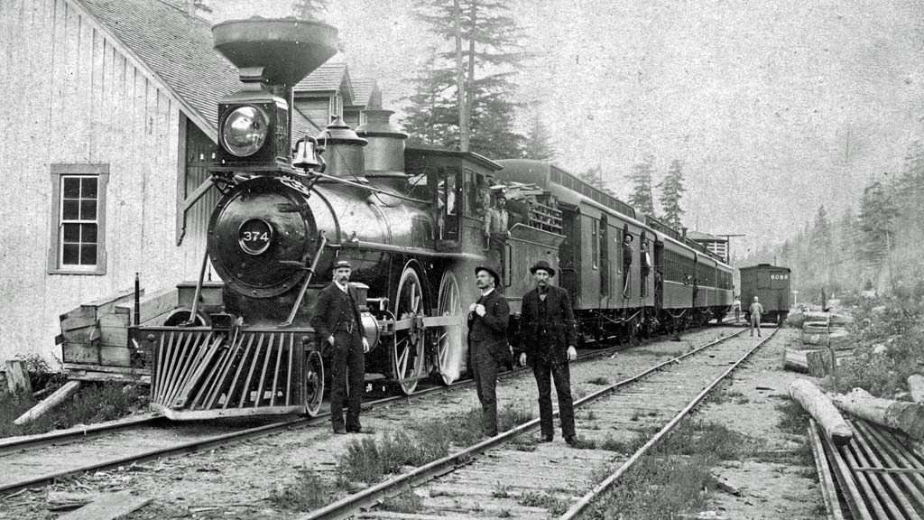
This article by Frank Leonard contains a title photograph showing Canadian Pacific Railway's locomotive number 374 with passenger cars stopped at a station named "Keefers". This turns out to be incorrect. Someone named the photographs location to be Keefers station, but judging by the number of windows and their position, this didn't seem possible when the photo was compared to other photos of Keefers station.
Ken Perry has solved this inconsistency. Here is his explanation:

The photo's location is Spuzzum with 374 being eastbound. What clinches my claim is the station layout, since only Yale and Spuzzum of the sixteen Onderdonk-era depots (a story in itself) were built "backwards" (more appropriately, the other fourteen were the backwards ones, as Yale and Spuzzum were built first) with the freight shed on the left as viewed from the track side with only two windows on the end versus four on the office end. Since the City of Vancouver Archives photo is clearly not Yale, it must be Spuzzum. I contacted Kira Baker at the City of Vancouver Archives to explain their photo was labelled incorrectly. Following is her response:
Dear Ken, in follow up to our earlier emails about descriptions of BC railway photographs, I am getting back to this image of a station you identified as Spuzzum. In reviewing the photograph from the VPL collection (Vancouver Public Library), as well as other Keefers station photographs, I have made the change to the place access point in our database. As to why Keefers was previously identified within our database, I am copying the notes created by Major Matthews when he incorporated this image to the City of Vancouver holdings:
"Canadian Pacific Railway, circa 1887. Transcontinental passenger train, Montreal to Vancouver. Engine No. 374, the locomotive which drew the first passenger train into Keefers, B.C. Vancouver, 23 May 1887. Left to right, John Gavin conductor, John Rooney railway mail service (later Supt.), Duke McKenzie "Bob" Drummond mail clerk in middle door, "Pete" Righter engineer in cab window, W.O. Miller (not shown) despatcher (living Vancouver 1944), Wood burner 2 foot lengths, Mr. Gavin 1st W.M. Acacia Lodge 1893, Mr. Rooney 1st City Clerk Vancouver but declined. Mr. McKenzie was at driving of last spike, Nov. 1885. Mr. Righter drove first train into Vancouver. Keefers an important point then and was headquarters. George A. Keefer, locating engineer. Mr. Rooney was postmaster at Granville, now Vancouver, in Feb 1886. This photo presented, March 1944, by his only child, Miss Norah Rooney of North Vidal Street in Sarnia, Ontario, when she visited the City Archives."
This still confuses the question about the direction of the train, east or westbound. The Major says westbound, Ken Perry says eastbound. I'm going to side with Ken Perry on this one.
Here are the photos from the Vancouver Public Library showing several of the Onderdonk constructed stations. Notice only Yale and Spuzzum have the freight shed and raised wooden platform on the left. North Bend is located where the Cascade and Thompson Subdivisions meet. Around 1887 the company constructed the hotel known as Fraser Canyon House designed by Thomas Charles Sorby who also designed Mount Stephen House at Field, and Glacier House near the Illecillewaet glacier. North Bend locomotive servicing facilities included a brick roundhouse shown with the 1885 station photo. The 1885 station appears to have been rebuilt or replaced with only one dormer about 1900.
 |
 |
 |
 |
 |
 |
 |
 |
William Slim - 21 November 2020.